🌈Earth Systems Science Unit 9 Review
9.1 Atmospheric circulation and global wind patterns
9.1 Atmospheric circulation and global wind patterns
Unit & Topic Study Guides
Earth Systems Science: An Introduction
Earth's Structure and Composition
Plate Tectonics: Earth's Dynamic Crust
Earthquakes & Volcanoes: Earth's Geohazards
Weathering, Erosion & Soil Formation
Hydrologic Cycle & Freshwater Systems
Ocean Circulation & Marine Ecosystems
Atmosphere: Composition and Structure
Weather Systems and Climate Patterns
Biogeochemical Cycles: C, N, and P
Terrestrial Biomes and Ecosystems
Climate Change & Air Pollution Impacts
Water Resources and Pollution
Human Impacts on Land and Soil
Biodiversity Loss: Human Impact & Conservation
Earth Systems: Interactions & Feedbacks
Earth Observation & Remote Sensing Technologies
Earth Systems Modeling: Methods & Uses
Sustainable Resources and Policy
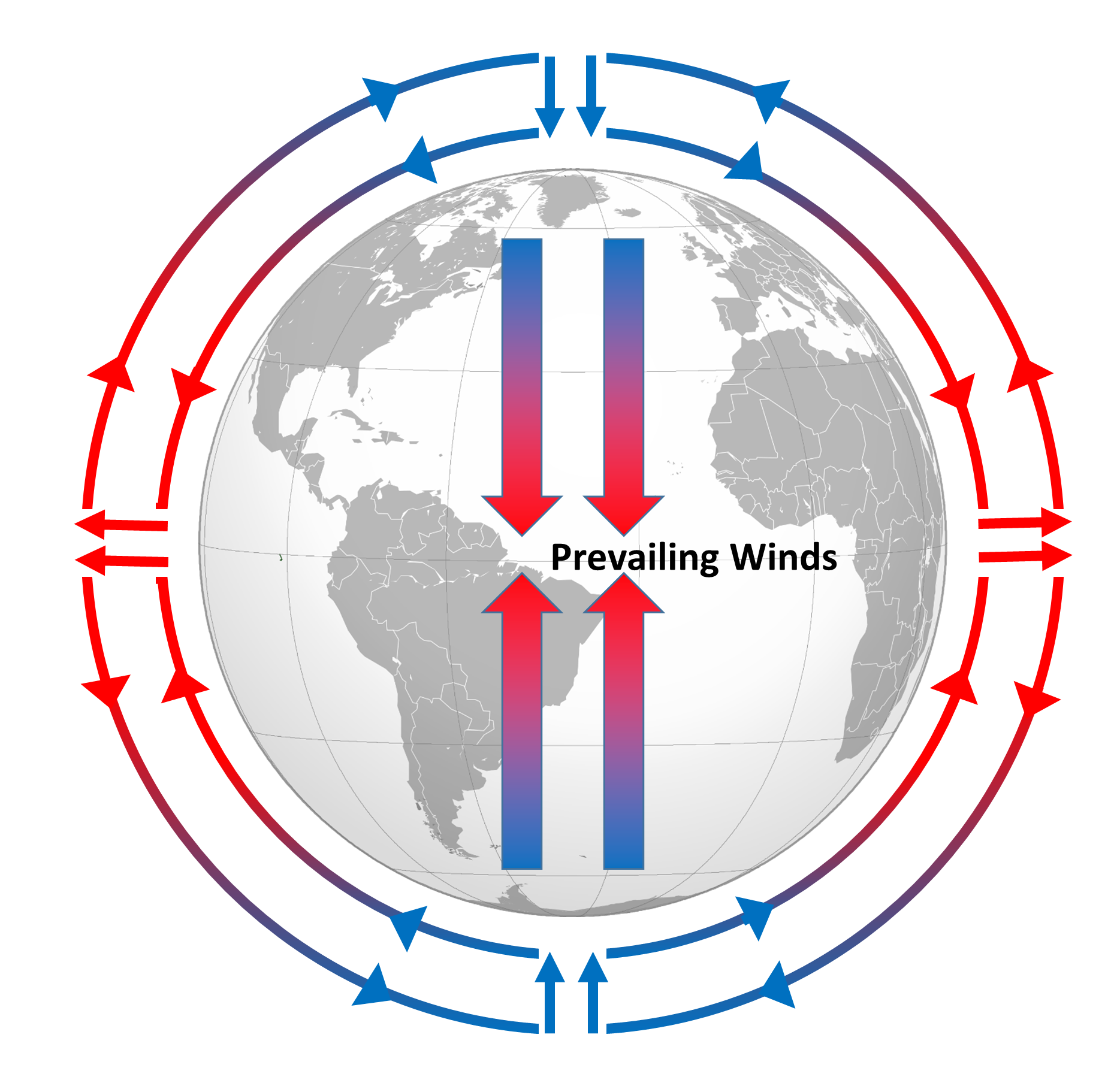
Global wind patterns shape weather and climate across the planet. They result from uneven solar heating and Earth's rotation working together. Understanding atmospheric circulation is central to predicting weather, explaining why deserts form where they do, and grasping how climate change may shift these patterns.
Three pairs of circulation cells move air between the equator and the poles. The wind belts they produce, including trade winds, westerlies, and jet streams, steer storms, distribute heat, and control precipitation worldwide.
Atmospheric Circulation Cells
Hadley Cell and Coriolis Effect
The Hadley cell is the largest and most powerful circulation cell. It operates in a four-step loop:
- Intense solar heating near the equator warms moist air, causing it to rise. This creates a zone of low pressure and heavy precipitation at the surface.
- The rising air flows poleward at high altitude, cooling as it goes.
- Around 30° latitude, the air has cooled and dried enough to sink, creating high pressure and dry conditions at the surface. This is why many of the world's major deserts (the Sahara, Arabian, and Sonoran deserts) cluster near 30°N and 30°S.
- At the surface, air flows back toward the equator, completing the loop.
The Coriolis effect is an apparent deflection caused by Earth's rotation. It deflects moving air to the right in the Northern Hemisphere and to the left in the Southern Hemisphere. Within the Hadley cell, the Coriolis effect bends the equatorward surface flow westward, producing the trade winds.
Mid-Latitude and Polar Cells
The Ferrel cell sits between the Hadley and Polar cells (roughly 30°–60° latitude). Unlike the Hadley cell, the Ferrel cell is an indirect circulation: it doesn't generate its own motion through heating and cooling but is driven by the cells on either side, almost like a gear turned by its neighbors.
- Air rises near 60° latitude, flows equatorward aloft, descends near 30° latitude, and returns poleward at the surface.
- Surface winds in this belt are deflected by the Coriolis effect to become the westerlies (blowing west to east).
The Polar cell is the smallest and weakest of the three.
- Cold, dense air sinks over the poles, creating high pressure.
- That air flows equatorward along the surface, rises near 60° latitude where it meets warmer mid-latitude air, and returns poleward aloft.
- This is a direct circulation, powered by the steep temperature gradient between the frigid poles and the relatively warmer air at 60°.
Global Wind Patterns
Trade Winds and Westerlies
Trade winds are the steady, prevailing winds between roughly 30° latitude and the equator in both hemispheres. They blow from the northeast in the Northern Hemisphere and from the southeast in the Southern Hemisphere. Historically, sailors relied on their consistency for transoceanic voyages.
Westerlies dominate the mid-latitudes (30°–60°) and blow from west to east. They form because the poleward surface flow in the Ferrel cell is deflected eastward by the Coriolis effect. Westerlies steer most mid-latitude weather systems, which is why storms in North America and Europe generally track from west to east.

Jet Streams
Jet streams are narrow ribbons of fast-moving wind in the upper atmosphere (typically near the tropopause, around 9–12 km altitude) that blow from west to east. They form at boundaries where sharp temperature contrasts exist between adjacent air masses.
- The polar front jet stream sits near the boundary between the Ferrel and Polar cells, roughly 50°–60° latitude on average but highly variable. It's the stronger of the two and has the greatest influence on mid-latitude weather, steering storms and separating cold polar air from warmer subtropical air.
- The subtropical jet stream sits near the boundary between the Hadley and Ferrel cells, around 30° latitude.
Jet stream winds can exceed 250 mph (400 km/h) in extreme cases, though typical peak speeds are around 100–200 mph. Their position shifts seasonally and can develop large north-south undulations (called Rossby waves) that pull cold air south or push warm air north, driving major weather events.
Pressure and Convergence Zones
Pressure Belts
Pressure belts are globe-encircling zones of relatively high or low atmospheric pressure. They map directly onto the circulation cells:
| Pressure Belt | Latitude | Characteristics |
|---|---|---|
| Equatorial low (doldrums) | ~0° | Rising air, low pressure, heavy rain |
| Subtropical highs (horse latitudes) | ~30°N and 30°S | Sinking air, high pressure, arid conditions |
| Subpolar lows | ~60°N and 60°S | Rising air, low pressure, frequent storms |
| Polar highs | ~90°N and 90°S | Sinking air, high pressure, cold and dry |
The subtropical highs correspond to the descending branch of the Hadley cell and are directly associated with the world's great desert belts. The subpolar lows mark where warm mid-latitude air collides with cold polar air, generating the storminess typical of places like Iceland and the Aleutian Islands.
Intertropical Convergence Zone (ITCZ)
The ITCZ is a narrow belt of low pressure near the equator where the Northern and Southern Hemisphere trade winds converge. All that converging air is forced upward, producing towering cumulonimbus clouds and some of the heaviest rainfall on Earth.
The ITCZ doesn't stay fixed. It migrates seasonally toward whichever hemisphere is tilted toward the sun, following the zone of maximum solar heating. This seasonal shift has enormous consequences for tropical regions:
- When the ITCZ moves overhead, a region gets its wet season.
- When it moves away, the dry season sets in.
Regions like the Sahel (the semi-arid belt south of the Sahara) and much of monsoon-affected South Asia depend on this annual migration for their rainfall. Even small shifts in the ITCZ's average position can mean the difference between adequate rain and drought.
The convergence of trade winds along the ITCZ also plays a key role in Earth's energy balance by transporting heat and moisture away from the equator through the Hadley circulation.