🌡️Intro to Climate Science Unit 9 Review
9.2 Reconstruction of past climates
9.2 Reconstruction of past climates
Unit & Topic Study Guides
Earth's Climate System: An Overview
Atmosphere: Composition and Structure
Radiation and Earth's Energy Balance
Atmospheric & Oceanic Circulation
Hydrologic Cycle in Climate Science
Carbon Cycle and Ecosystems
Climate Forcings and Feedbacks
Natural Climate Variability
Climate Proxies: Decoding Earth's Past
Greenhouse Gases: Enhanced Effect
Recent Climate Change Observations
Climate Models: Forecasting Earth's Future
Climate Impacts on Natural Systems
Climate Change: Impacts on Human Systems
Climate Mitigation and Emission Reduction
Climate Change Adaptation Strategies
Climate Policy & Global Negotiations
Principles and Methods of Paleoclimate Reconstruction
Paleoclimate reconstruction pieces together Earth's climate history using proxy data: physical, chemical, or biological records that preserve information about past conditions. Because no one was around to measure temperature millions of years ago, scientists rely on natural archives like tree rings, ice cores, and ocean sediments to fill in the gaps. The accuracy of these reconstructions depends on a few core principles and careful interpretation of each proxy's strengths and limits.
Principles of paleoclimate reconstruction
Proxy data provide indirect evidence of past climate. When climate variables like temperature or rainfall change, they leave fingerprints in natural materials. Tree rings grow wider in favorable years. Ice traps tiny bubbles of ancient air. Coral skeletons record ocean chemistry. The challenge is reading those fingerprints correctly, which requires the principles below.
- Uniformitarianism assumes that the same physical, chemical, and biological processes operating today also operated in the past. If warmer water produces a certain chemical signature in a coral today, scientists assume the same relationship held thousands of years ago.
- Correlation establishes relationships between proxy records and climate variables by comparing patterns in the proxy data with observed or modeled climate data. If a proxy tracks modern temperature well, it's reasonable to use it for past temperature estimates.
- Calibration turns those correlations into numbers. Using statistical methods like regression analysis, scientists develop equations that convert proxy measurements (say, ring width in millimeters) into quantitative climate estimates (degrees Celsius).
- Dating methods pin proxy records to a timeline. These include:
- Radiometric techniques such as radiocarbon dating (for organic materials up to ~50,000 years old) and uranium-series dating (for carbonates up to ~500,000 years old)
- Incremental dating by counting annual layers in tree rings, varves (layered lake sediments), or ice cores
- Relative dating through stratigraphy (older layers sit below younger ones) and biostratigraphy (using fossil assemblages to assign relative ages)

Interpretation of paleoclimate data
Different proxies are suited to different climate variables. Most proxies respond to more than one variable, so interpretation requires care.
Temperature proxies
- The isotopic composition of oxygen () in ice cores, speleothems, and foraminifera shells shifts with temperature and global ice volume. In ice cores, for example, more negative values generally indicate colder conditions because heavier water molecules preferentially rain out before reaching polar regions during warm periods.
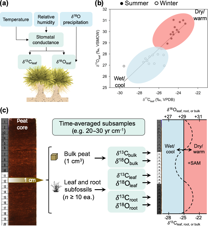
- Tree ring width and density respond to growing-season temperature. In cold-limited environments (like high-latitude or high-altitude forests), wider rings typically correspond to warmer years. These records can be calibrated against instrumental temperature data.
- Mg/Ca ratios in foraminifera shells and coral skeletons increase with water temperature during calcification, providing an independent temperature estimate that complements .
Precipitation proxies
- Tree ring width and density are also sensitive to moisture availability. In dry-limited environments, wider rings signal wetter years, making tree rings useful for reconstructing drought history.
- Pollen assemblages in lake and ocean sediments reflect past vegetation communities. Since plant distributions are shaped by temperature and rainfall, shifts in pollen types reveal changes in regional climate.
- and (hydrogen isotope ratios) in speleothems and ice cores are affected by the amount and source of precipitation. Heavier rainfall events or shifts in moisture source regions alter these ratios.
Atmospheric composition proxies
- Air bubbles trapped in ice cores are direct samples of past atmosphere. Scientists measure concentrations of , , and from these bubbles, providing a record stretching back roughly 800,000 years.
- The isotopic composition of carbon () in tree rings and sediments responds to changes in atmospheric and carbon cycle dynamics. Plants preferentially take up lighter , so shifts in can signal changes in carbon sources or sinks.
- Stomatal density in fossil leaves decreases when atmospheric rises (plants need fewer stomata to absorb the same amount of carbon). This provides an independent estimate of past levels, useful for periods not covered by ice core records.
Strengths, Weaknesses, and Resolution of Paleoclimate Reconstructions
No single proxy tells the whole story. Each archive covers a different time span, geographic area, and level of detail. Combining multiple proxies gives a more complete and reliable picture.
Paleoclimate techniques: strengths vs weaknesses
Ice cores
- Strengths: High-resolution records (annual to sub-annual) of temperature, precipitation, and atmospheric composition. They contain direct samples of past air, which is unique among proxies.
- Weaknesses: Limited to polar regions and a few high-altitude glaciers. Post-depositional processes like gas diffusion and occasional melt layers can blur the signal. The oldest continuous ice core record extends to about 800,000 years, though efforts are underway to reach older ice.
Tree rings
- Strengths: Annual resolution with precise dating through cross-dating (matching ring patterns across many trees). Wide spatial coverage across continents, and sensitivity to both temperature and precipitation.
- Weaknesses: Temporal coverage is limited to a few millennia in most regions (the longest continuous records reach back around 10,000 years using subfossil wood). Non-climatic factors like tree age, competition for light, pest outbreaks, and human land use can influence ring growth and complicate interpretation.
Sediment cores
- Strengths: Can span millions of years, offering the longest continuous climate records available. They contain diverse proxy indicators (pollen, diatoms, foraminifera, geochemical markers) and can be collected from lakes, oceans, and peat bogs worldwide.
- Weaknesses: Temporal resolution is typically decadal to millennial. Bioturbation (mixing by burrowing organisms) and diagenesis (chemical alteration after burial) can disturb the record. Dating uncertainties arise from radiocarbon reservoir effects and reworking of older sediments.
Corals and speleothems
- Strengths: High temporal resolution (annual to sub-annual) with growth bands that can be counted like tree rings. Sensitive to temperature and precipitation changes. Uranium-series dating provides accurate absolute ages.
- Weaknesses: Corals are restricted to tropical and subtropical oceans; speleothems to caves. Non-climatic factors (nutrient availability for corals, cave ventilation for speleothems) can influence the record. Growth hiatuses or diagenetic alteration may create gaps.
Resolution in paleoclimate reconstructions
Spatial resolution
- Depends on the geographic distribution and density of proxy sites
- Higher in regions with abundant records, such as temperate and boreal forests (tree rings) or tropical oceans (corals)
- Lower in regions with sparse records, such as polar ice sheets, deep ocean basins, and deserts
Temporal resolution
- Varies by proxy type and dating method
- Annual to sub-annual: tree rings, corals, speleothems, varved lake and marine sediments
- Decadal to centennial: ice cores (at greater depths where annual layers thin), non-varved sediments, peat deposits
- Millennial to orbital: deep-sea sediments, loess deposits, paleosols
Limitations and uncertainties
- Proxy-climate relationships can change over time, a problem called non-stationarity. For example, a tree species that responds mainly to temperature today might become more moisture-limited if rainfall patterns shift.
- Combining multiple proxy records with different resolutions and uncertainties requires careful statistical methods and data harmonization to avoid introducing artifacts.
- Spatial and temporal gaps in the proxy network limit the ability to reconstruct truly global climate patterns and can bias reconstructions toward regions with denser coverage.