🏝️Earth Science Unit 3 Review
3.1 Landforms and Landscapes
3.1 Landforms and Landscapes
Unit & Topic Study Guides
Earth's Place in the Universe
Earth's Systems and Cycles
Earth's Surface Processes
Earth's History and Geologic Time
Earth's Atmosphere and Climate
Earth's Oceans and Marine Ecosystems
Earth's Mineral and Energy Resources
Natural Hazards and Earth's Processes
Earth's Ecosystems and Biomes
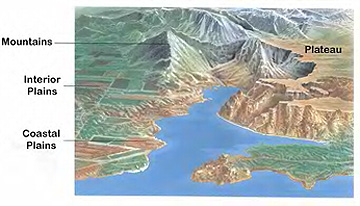
Major Landforms and Characteristics
Landforms are natural physical features on Earth's surface. Each type has distinct characteristics shaped by the processes that formed it and the materials it's made of.

Types of Landforms
Mountains have steep slopes and high elevations. They form primarily through tectonic plate collisions or volcanic eruptions. The Himalayas, for example, rose from the collision of the Indian and Eurasian plates and continue to grow by a few millimeters each year.
Valleys are low-lying areas between hills or mountains. They take different shapes depending on what carved them:
- V-shaped valleys are cut by rivers over time as flowing water erodes downward into rock
- U-shaped valleys are carved by glaciers, which grind out wide, flat-bottomed troughs
- Rift valleys form where tectonic plates pull apart, causing the land between them to drop (the East African Rift Valley is a major example)
Plateaus are elevated, flat-topped landforms with steep sides. They often form when tectonic forces push a broad area of land upward, and erosion then shapes the edges. The Colorado Plateau and Tibetan Plateau are two well-known examples.
Plains are extensive, relatively flat areas typically formed by sediment deposition. Coastal plains form along shorelines, while alluvial plains build up from sediment deposited by rivers over long periods.
Landform Categories and Formation
Mountains can be further categorized by how they formed:
- Fold mountains form when plates collide and compress rock layers into folds (Himalayas)
- Fault-block mountains form when blocks of rock are pushed up along faults (Sierra Nevada)
- Dome mountains form when magma pushes up the crust without breaking through (Black Hills)
- Volcanic mountains build up from erupted material (Mount Fuji)
Other notable landforms include canyons (deep, narrow valleys cut by rivers, like the Grand Canyon), mesas (flat-topped hills with steep sides, like Table Mountain), buttes (smaller, more isolated versions of mesas, like those in Monument Valley), and deltas (fan-shaped deposits of sediment where rivers meet a body of water, like the Mississippi River Delta).
Processes Shaping Earth's Surface
Tectonic and Volcanic Processes
Tectonic processes driven by plate movements are responsible for building many of Earth's largest landforms. These movements cause:
- Folding, where compressive forces crumple rock layers into folds, creating fold mountains
- Faulting, where rocks crack and shift along fracture lines, creating fault-block mountains
- Uplift, where broad areas of crust are pushed upward, creating plateaus
Volcanic activity adds another dimension. Eruptions build stratovolcanoes (steep, layered volcanic mountains), while massive eruptions can collapse the ground into calderas (like the Yellowstone Caldera). Repeated lava flows over millions of years can also create lava plateaus, such as India's Deccan Traps.
Weathering, Erosion, and Deposition
These three processes work as a sequence: weathering breaks rock down, erosion moves the broken material, and deposition drops it somewhere new.
Weathering breaks down rocks and minerals at or near Earth's surface. It comes in three forms:
- Mechanical (physical) weathering physically breaks rock apart without changing its chemistry. Freeze-thaw cycles are a common example: water seeps into cracks, freezes and expands, then widens the crack over time. Salt crystallization works similarly, with growing salt crystals prying rock apart.
- Chemical weathering changes the mineral composition of rock. Carbonation dissolves carbonate rocks like limestone when they react with slightly acidic rainwater. Oxidation causes iron-bearing minerals to rust and weaken.
- Biological weathering involves living organisms, such as tree roots growing into cracks or lichens producing acids that dissolve rock surfaces.
Erosion removes and transports the weathered material. The main agents are:
- Water (fluvial erosion) carries sediment in rivers and streams, and waves erode coastlines
- Wind (aeolian erosion) picks up and blasts fine particles against rock surfaces
- Ice (glacial erosion) grinds rock as glaciers move, through plucking (pulling rock fragments loose) and abrasion (scraping the bedrock)
- Gravity (mass wasting) pulls rock and soil downslope through landslides, rockfalls, and slow creep
Deposition occurs when the transporting agent loses energy and drops its sediment load. This builds landforms like deltas, floodplains, beaches, and alluvial fans. Over time, deposited sediment can compact and cement into sedimentary rocks such as sandstone and limestone.
Glaciation and Fluvial Processes
Glaciers reshape landscapes dramatically. As they advance, they erode through plucking and abrasion, carving out distinctive features:
- U-shaped valleys with wide, flat floors and steep walls
- Cirques, amphitheater-shaped basins scooped out at the head of a glacier
- Arêtes, sharp knife-edge ridges that form between two adjacent glacial valleys
When glaciers melt and retreat, they deposit sediment in features called moraines (ridges of debris) and drumlins (elongated, teardrop-shaped hills).
Fluvial processes (the action of rivers and streams) create their own set of landforms. A river starts by cutting a narrow V-shaped valley. As it matures, it develops meanders, which are sinuous bends. When a meander gets cut off from the main channel, it becomes an oxbow lake. Where a fast-moving stream exits a mountain canyon onto a flat plain, it spreads its sediment into an alluvial fan.
Tectonics and Landform Development
Plate Boundaries and Landforms
The movement of Earth's lithospheric plates is the primary force behind the creation and reshaping of large-scale landforms. Different types of plate boundaries produce different results:
- Convergent boundaries (plates colliding) build mountain ranges. The specific result depends on what's colliding: two continental plates produce fold mountains like the Himalayas, while an oceanic plate diving under a continental plate creates volcanic ranges like the Cascades and the Andes.
- Divergent boundaries (plates pulling apart) create rift valleys on land, like the East African Rift Valley, and mid-ocean ridges on the seafloor, like the Mid-Atlantic Ridge.
- Transform boundaries (plates sliding past each other) produce fault zones. California's San Andreas Fault is the most well-known example, where the Pacific and North American plates grind laterally past one another.

Hotspots and Isostatic Adjustment
Hotspots are areas of persistent volcanic activity that are not located at plate boundaries. They sit above stationary plumes of hot material rising from deep in the mantle. As a tectonic plate drifts over a hotspot, a chain of volcanoes forms. The Hawaiian Islands were created this way: the oldest islands in the chain are farthest from the current hotspot position, while the Big Island (directly over the hotspot today) is the youngest and most volcanically active. The Emperor Seamount chain extends this pattern even further northwest beneath the Pacific.
Isostatic adjustment is the vertical movement of Earth's crust in response to changes in the weight pressing down on it. Think of it like a boat in water: add cargo and it sinks lower; remove cargo and it rises. During ice ages, massive ice sheets pushed the crust downward. After the ice melted, the crust slowly rebounded upward. This isostatic rebound is still happening in places like Scandinavia and around the Baltic Sea, where coastlines are gradually rising and new land is emerging from the sea.
Weathering and Erosion in Landscape Evolution
Weathering Processes and Landforms
Weathering and erosion are continuous processes that work together to break down and reshape landscapes over geologic time.
Physical weathering creates distinctive features. Repeated freeze-thaw cycles can isolate blocks of resistant rock into tors (exposed rock outcrops on hilltops) and produce talus slopes (piles of angular rock debris at the base of cliffs).
Chemical weathering transforms landscapes in different ways. Where limestone is abundant, carbonation dissolves the rock and creates karst topography, a landscape characterized by sinkholes, caves, disappearing streams, and underground drainage systems. Chemical weathering also plays a central role in developing soil profiles, the layered structure of soil from the organic-rich topsoil down to the partially weathered bedrock below.
Erosional Processes and Landscape Evolution
Erosion driven by water, wind, ice, and gravity sculpts some of Earth's most recognizable features. Rivers carve canyons like the Grand Canyon over millions of years. Waves undercut rock to form sea cliffs like the White Cliffs of Dover. Wind shapes vast fields of sand dunes across deserts like the Sahara.
The rate of weathering and erosion depends on several interacting factors:
- Climate: More precipitation and higher temperatures generally accelerate both chemical and physical weathering
- Rock type: Some rocks resist weathering better than others (granite weathers slowly; limestone dissolves relatively quickly)
- Vegetation cover: Plant roots stabilize soil and slow erosion; bare ground erodes much faster
- Topography: Steeper slopes experience faster erosion because gravity pulls water and debris downhill more forcefully
Landscape evolution results from the long-term interplay of tectonic uplift, weathering, erosion, and deposition. The Himalayas continue to rise from plate collision while simultaneously being worn down by weathering and river erosion. Barrier islands along coastlines shift and reshape with every storm. Distinctive erosional features like the hoodoos of Bryce Canyon form where softer rock erodes away beneath a cap of harder rock, leaving tall, pillar-like formations standing. These examples show that Earth's surface is never truly static; it's always being built up and broken down at the same time.