🏝️Earth Science Unit 6 Review
6.1 Ocean Basins and Seafloor Features
6.1 Ocean Basins and Seafloor Features
Unit & Topic Study Guides
Earth's Place in the Universe
Earth's Systems and Cycles
Earth's Surface Processes
Earth's History and Geologic Time
Earth's Atmosphere and Climate
Earth's Oceans and Marine Ecosystems
Earth's Mineral and Energy Resources
Natural Hazards and Earth's Processes
Earth's Ecosystems and Biomes
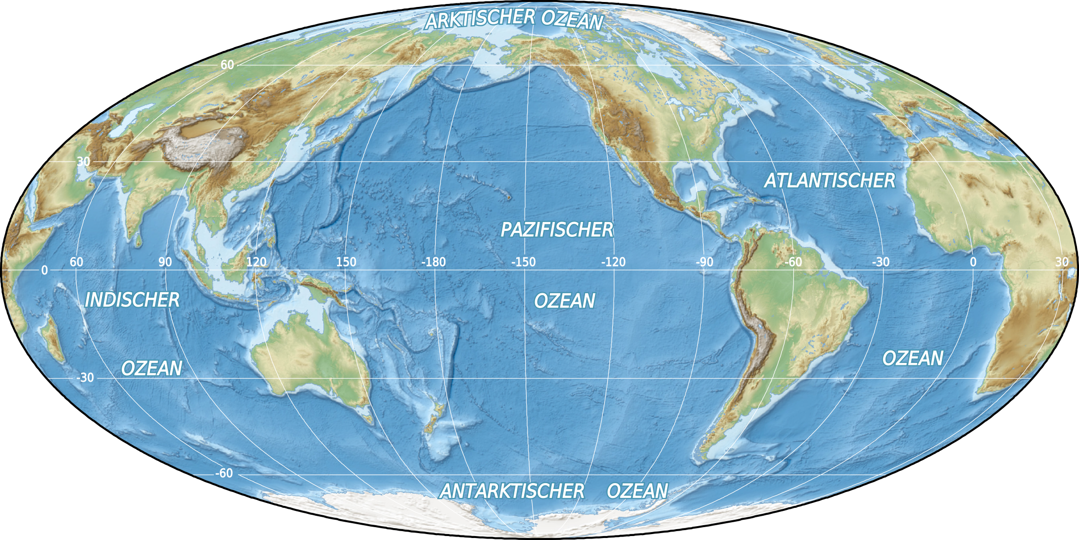
Ocean basins are the massive depressions in Earth's surface that hold the world's oceans. They're far from featureless: the seafloor contains mountain ranges, deep trenches, vast plains, and gently sloping shelves, all shaped by plate tectonics over millions of years. Understanding these features connects directly to how ocean currents flow, where marine life thrives, and how Earth's climate operates.
Major Ocean Basins and Locations

The Five Major Ocean Basins
Earth has five major ocean basins: the Pacific, Atlantic, Indian, Southern (Antarctic), and Arctic. Each differs in size, depth, and the tectonic forces acting on it. Together, they cover about 71% of Earth's surface and drive global ocean circulation and climate patterns.
Geographical Locations and Boundaries
- The Pacific Ocean is the largest and deepest basin, stretching between the Americas to the east and Asia and Australia to the west. It covers more area than all of Earth's landmasses combined.
- The Atlantic Ocean separates the Americas from Europe and Africa, extending from the Arctic in the north to the Southern Ocean.
- The Indian Ocean is bounded by Africa to the west, Asia to the north, and Australia to the east.
- The Southern Ocean encircles Antarctica, extending from the continent's coast northward to 60°S latitude. It was officially recognized as a distinct ocean by the International Hydrographic Organization in 2000.
- The Arctic Ocean is the smallest and shallowest basin, centered around the North Pole and largely covered by sea ice.
Continental Margins: Shelves, Slopes, and Rises
Continental margins are the transition zones between continental land and the deep ocean floor. They have three main parts, each with a different slope and depth profile.
Continental Shelves
Continental shelves are the submerged, gently sloping extensions of the continents. They form through sediment accumulation and changes in sea level over time.
- Shelves are the shallowest ocean zones, averaging about 130 meters deep. Their width varies enormously, from just a few kilometers to over 1,500 kilometers (the Gulf of Mexico has an especially wide shelf).
- Because sunlight penetrates these shallow waters, continental shelves support abundant marine life and are some of the most biologically productive areas in the ocean.
- Shelves also hold significant oil and gas reserves. The North Sea is a well-known example of a shelf region with major fossil fuel extraction.
Continental Slopes and Rises
Beyond the shelf edge, the seafloor drops off steeply at the continental slope, which connects the shelf to the deep ocean floor at an average gradient of about 4°.
- Slopes are often carved by submarine canyons, such as Monterey Canyon off the California coast. These canyons channel sediment-laden flows called turbidity currents, which are essentially underwater landslides that carry sediment downslope at high speed.
- The steepness of a continental slope depends on the tectonic setting and the type of sediment present.
At the base of the slope, sediment deposited by turbidity currents accumulates into the continental rise, a gently sloping apron of material.
- Rises have a much lower gradient than slopes and can extend for hundreds of kilometers before flattening into the abyssal plains. The Atlantic Continental Rise is a classic example.
- The layers of sediment in continental rises act as a geological record, preserving information about past climate conditions, ocean circulation, and tectonic events.
Deep Ocean Floor Features

Abyssal Plains
Abyssal plains are the vast, remarkably flat regions of the deep ocean floor, typically found at depths between 3,000 and 6,000 meters. They're among the flattest places on Earth.
- These plains are blanketed by fine-grained sediments, mostly clay and the tiny shells of dead marine organisms like foraminifera that slowly rain down from above.
- Conditions here are extreme: near-freezing temperatures, crushing pressure, and total darkness. Life is sparse but unique, including organisms like xenophyophores (giant single-celled creatures that live on the sediment surface).
- Abyssal plains cover a huge portion of Earth's surface and play a significant role in global carbon cycling, since organic material that sinks here gets locked away in sediments.
Ocean Trenches and Seamounts
Ocean trenches are the deepest features on Earth's surface, formed where one oceanic plate dives beneath another at a subduction zone.
- The Mariana Trench in the western Pacific reaches over 11,000 meters deep, making it the deepest known point in the ocean.
- Trenches are associated with intense seismic and volcanic activity. The subducting plate generates earthquakes, and melting of the plate at depth fuels volcanic arcs on the overriding plate, like the Aleutian Islands.
- Despite the extreme pressure and darkness, trenches support specially adapted organisms, including certain species of amphipods and snailfish. (Giant tube worms are actually found at hydrothermal vents on mid-ocean ridges, not in trenches themselves.)
Seamounts are underwater volcanic mountains that rise at least 1,000 meters above the surrounding seafloor without breaking the ocean surface.
- Most are volcanic in origin, formed by magma extruding from the mantle. The Hawaiian-Emperor seamount chain is a well-known example, created as the Pacific Plate moved over a stationary hotspot.
- Seamounts are biodiversity hotspots. They provide hard rocky surfaces for organisms like deep-water corals to attach to, and the currents deflected around them create upwelling zones that bring nutrients to shallower water, supporting rich ecosystems.
Seafloor Spreading and Plate Tectonics
Mid-Ocean Ridges and Seafloor Spreading
Seafloor spreading is the process that creates new oceanic crust. Here's how it works:
- At a divergent plate boundary, two tectonic plates pull apart from each other.
- Hot magma from the mantle wells up to fill the gap between the separating plates.
- The magma cools and solidifies, forming new oceanic crust.
- Over time, this new crust moves away from the ridge as more magma continues to rise and solidify behind it.
The result is a mid-ocean ridge, an underwater mountain range that runs along the divergent boundary. The Mid-Atlantic Ridge is the most famous example, running roughly down the center of the Atlantic Ocean for about 16,000 kilometers. Convection currents in Earth's mantle provide the driving force behind this process.
Plate Tectonics and Ocean Basin Evolution
Plate tectonics explains how Earth's lithospheric plates move and interact, and it's the framework for understanding how ocean basins form and change.
- Oceanic crust is born at mid-ocean ridges, travels across the seafloor over millions of years, and is eventually pulled back into the mantle at subduction zones. The Pacific Plate is a good example of a plate undergoing this full cycle.
- Because of this process, oceanic crust gets progressively older the farther it is from a mid-ocean ridge. The oldest oceanic crust on Earth is only about 200 million years old, since older crust has already been recycled through subduction.
- Over geologic time, plate movements can open new ocean basins, widen existing ones, or close them entirely. The ancient Tethys Ocean, for instance, once separated the supercontinents of Laurasia and Gondwana before closing as the continents collided.
Two key lines of evidence support seafloor spreading:
- Magnetic anomalies: As new crust forms at ridges, iron-bearing minerals in the cooling rock align with Earth's magnetic field. Because the field periodically reverses polarity, the seafloor records a symmetrical pattern of magnetic stripes on either side of the ridge. This is known as the Vine-Matthews-Morley hypothesis, and it was one of the strongest early confirmations of seafloor spreading.
- Sediment thickness: Sediment layers on the seafloor get thicker with distance from the ridge. Near the ridge, crust is young and has had little time to accumulate sediment. Farther away, the older crust has been collecting material for millions of years. Data from the Deep Sea Drilling Project confirmed this pattern.