🌡️Climatology Unit 4 Review
4.3 Deep ocean circulation and thermohaline circulation
4.3 Deep ocean circulation and thermohaline circulation
Unit & Topic Study Guides
Introduction to Climatology
Earth's Energy Balance
Atmospheric Circulation
Ocean Circulation and Climate
Hydrologic Cycle and Precipitation
Climate Zones and Biomes
Paleoclimatology and Climate Proxies
Climate Modeling and Projections
Anthropogenic Climate Change
Climate Impacts and Adaptation
Climate Policy and Economics
Deep ocean circulation
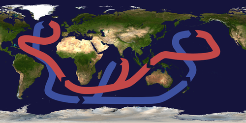
Global ocean conveyor belt system
Deep ocean circulation moves water through the deepest layers of the world's oceans along a path often called the global ocean conveyor belt. This circulation is driven by differences in water density, which arise from variations in temperature and salinity.
At high latitudes, cold, dense water sinks toward the ocean floor. The two primary sinking regions are the North Atlantic (around Greenland and the Labrador Sea) and the Southern Ocean near Antarctica. Once this water reaches depth, it spreads slowly across ocean basins, eventually rising back to the surface through upwelling, which brings nutrient-rich deep water toward the surface and fuels marine productivity.
Wind-driven surface currents interact with and feed into this deep circulation, but the timescales are vastly different. A parcel of water in the deep conveyor belt can take roughly 1,000 to 1,500 years to complete a full circuit around the globe.
Formation of deep water masses
Dense water masses form in a few specific high-latitude regions where conditions are right for surface water to become heavy enough to sink. The two most important deep water masses are:
- North Atlantic Deep Water (NADW) — forms primarily in the Labrador Sea and the Nordic Seas (between Greenland, Iceland, and Norway). Surface waters cool dramatically in winter and become saltier as sea ice forms (ice excludes salt, leaving the remaining water more saline). This cold, salty water is dense enough to sink to depths of 2,000–4,000 meters.
- Antarctic Bottom Water (AABW) — forms mainly in the Weddell Sea and Ross Sea near Antarctica. Extreme cooling and brine rejection during sea ice formation produce the densest water mass in the global ocean, sinking to the very bottom (below 4,000 meters).
Once these dense water masses sink, they displace less dense water and initiate deep currents that flow along the ocean floor. A process called caballing can add further complexity: when two water masses with different temperature-salinity properties mix, the resulting mixture can actually be denser than either original water mass, driving additional sinking.
Vertical structure and movement
The ocean has a layered vertical density structure known as stratification. Lighter, warmer water sits on top; colder, denser water lies below. The boundary zone where density changes rapidly with depth is called the pycnocline.
Density gradients between adjacent water masses create pressure gradients, and these pressure differences drive horizontal movement in the deep ocean. Strong, stable stratification resists vertical mixing and can weaken deep circulation, while weaker stratification (common at high latitudes in winter) allows convection and sinking to occur more easily.
Thermohaline circulation
Density-driven ocean circulation
Thermohaline circulation refers to the large-scale ocean circulation driven by density differences that result from variations in temperature (thermo-) and salinity (-haline). The global conveyor belt model is a simplified way to visualize how these deep currents connect all major ocean basins.
The key components are:
- NADW formation in the North Atlantic, where cold, salty water sinks and flows southward at depth
- AABW formation near Antarctica, where even denser water sinks and spreads northward along the ocean floor
- Upwelling zones in the Indian and Pacific Oceans, where deep water gradually returns to the surface
As this water circulates, it transports heat, dissolved gases (including ), and nutrients across ocean basins, making thermohaline circulation a central mechanism in global climate regulation.
Surface and deep circulation connections
Surface currents are an integral part of the conveyor belt. The Gulf Stream, for example, carries warm, salty water from the tropics northward into the North Atlantic. As this water releases heat to the atmosphere (helping keep Western Europe relatively mild), it cools, becomes denser, and eventually sinks to form NADW. That sinking "pulls" more warm surface water northward, sustaining the cycle.
Changes in freshwater input can disrupt this connection. Increased glacial melt or greater river discharge into the North Atlantic adds freshwater, reducing surface salinity and making the water less dense. If the water becomes too light to sink, NADW formation weakens, potentially slowing or reorganizing the entire conveyor belt.
Timescales and global impact
Thermohaline circulation operates on timescales of centuries to millennia, far slower than wind-driven surface currents. Despite this slow pace, its effects on climate are profound:
- Heat distribution — It moves enormous quantities of heat from the tropics toward the poles, influencing regional climates worldwide.
- Carbon sequestration — Deep water carries dissolved to the ocean floor, where it can remain locked away for hundreds to thousands of years. This makes the deep ocean one of Earth's largest carbon reservoirs.
- Abrupt climate shifts — Changes in the strength or pattern of thermohaline circulation have been linked to rapid climate events in Earth's past, most notably the Younger Dryas (~12,900–11,700 years ago), when a sudden influx of freshwater into the North Atlantic likely shut down NADW formation and plunged the Northern Hemisphere back into near-glacial conditions within decades.
Density differences in ocean circulation
Factors affecting seawater density
Two properties control seawater density:
- Temperature — Colder water is denser. Cooling at high latitudes increases density and promotes sinking.
- Salinity — Saltier water is denser. Processes that increase salinity (evaporation, sea ice formation) raise density; processes that decrease salinity (precipitation, river runoff, ice melt) lower it.
The combined effect of temperature and salinity determines a water mass's overall density. In most of the ocean, temperature is the dominant factor, but in polar regions where temperatures are already near freezing, small salinity changes can tip the balance.
Regional density variations
The densest surface waters form in regions where cooling and salinity increases overlap:
- North Atlantic — Strong winter cooling combined with relatively high salinity (carried northward by the Gulf Stream) produces NADW.
- Southern Ocean — Extreme cold and brine rejection during sea ice formation produce AABW, the densest water mass in the ocean.
- Subtropical gyres — High evaporation rates create salty surface water, but warm temperatures keep this water relatively light. It contributes to salinity transport rather than deep water formation.

Density-driven circulation processes
The basic sequence works like this:
- Surface water at high latitudes cools and/or becomes saltier, increasing its density.
- Once dense enough, the water sinks (a process called convection) to the deep ocean.
- This sinking displaces less dense water, pushing it horizontally.
- Horizontal density gradients between water masses create pressure differences that drive large-scale deep currents.
- Deep water slowly spreads across ocean basins and eventually upwells back to the surface, completing the loop.
Caballing can intensify this process at boundaries where different water masses meet, producing water denser than either source.
Importance of deep ocean circulation
Global heat distribution
The conveyor belt redistributes heat on a planetary scale. Warm surface currents carry tropical heat poleward, while cold deep currents carry polar water toward the equator. This heat transport has direct effects on regional climates:
- Western boundary currents like the Gulf Stream and the Kuroshio Current carry warm water poleward along the western edges of ocean basins, warming nearby coastlines.
- The heat released by the Gulf Stream into the atmosphere keeps Western Europe significantly warmer than other regions at the same latitude (London, at 51°N, has milder winters than Labrador, Canada, at the same latitude).
This heat redistribution contributes to climate variability on seasonal, decadal, and centennial timescales.
Climate regulation and carbon cycle
Deep ocean circulation plays a critical role in the global carbon cycle. Surface waters absorb from the atmosphere, and when those waters sink, they carry dissolved carbon to the deep ocean. This carbon can remain sequestered for 500 to 1,000+ years before upwelling returns it to the surface.
The ocean's massive heat storage capacity also buffers atmospheric temperature changes, slowing the pace of warming or cooling. However, if circulation patterns shift, this buffering can break down. The Younger Dryas is the most dramatic example: a likely shutdown of NADW formation triggered cooling of 5–10°C across parts of the Northern Hemisphere in just a few decades.
Marine ecosystem impacts
Deep circulation shapes marine ecosystems by controlling where nutrients end up:
- Upwelling zones bring nitrogen, phosphorus, and iron from the deep ocean to the sunlit surface layer, fueling phytoplankton blooms and supporting productive fisheries (e.g., off the coasts of Peru and West Africa).
- Oxygen distribution depends on circulation patterns. Deep waters carry dissolved oxygen from the surface to the abyss; where circulation is sluggish, oxygen-minimum zones develop.
- Global biogeochemical cycles of carbon, nitrogen, and phosphorus are all tightly linked to how and where deep water moves.
Atmospheric-oceanic interactions
Deep ocean circulation interacts with atmospheric systems in ways that influence weather and climate globally. The El Niño-Southern Oscillation (ENSO), while primarily a surface and upper-ocean phenomenon, is influenced by the background state of ocean heat content that deep circulation helps set.
Changes in ocean heat transport also affect:
- Monsoon systems — Shifts in sea surface temperature patterns alter moisture availability and monsoon strength.
- Storm tracks — The temperature contrast between warm ocean currents and cooler surrounding waters influences where mid-latitude storms form and how intense they become.
These interactions highlight that the ocean and atmosphere function as a coupled system, with deep circulation acting as the slow, powerful component that sets the stage for faster atmospheric variability.