☁️Meteorology Unit 7 Review
7.4 Pressure gradient force and Coriolis effect
7.4 Pressure gradient force and Coriolis effect
Unit & Topic Study Guides
Earth's Atmosphere: Meteorology Basics
Atmospheric Composition and Structure
Solar Radiation and Earth's Energy Balance
Atmospheric Temperature and Heat Transfer
Atmospheric Moisture and Humidity
Cloud Formation and Precipitation Processes
Atmospheric Pressure and Wind
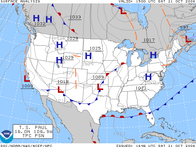
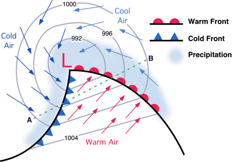
Air Masses and Fronts
Mid–Latitude Cyclones and Anticyclones
Thunderstorms and Tornadoes
Tropical Weather Systems and Hurricanes
Global Circulation Patterns and Climate Zones
Weather Forecasting Methods and Tools
Meteorological Instruments and Data Analysis
Climate Change: Impacts on Weather Patterns
Pressure gradient force and atmospheric motion
Fundamentals of pressure gradient force
The pressure gradient force (PGF) is the fundamental driver of wind. Differences in atmospheric pressure between two locations create a force that pushes air from higher pressure toward lower pressure, and that push is what gets air moving in the first place.
On a weather map, PGF acts perpendicular to isobars (lines of equal pressure), pointing from high to low pressure. Its strength depends on two things: how large the pressure difference is and how close together those pressure readings are. Tightly packed isobars mean a steep pressure gradient and stronger winds.
- PGF is directly proportional to the pressure difference and inversely proportional to the distance between measurement points
- It determines the initial speed and direction of air movement, which other forces then modify
- PGF drives both large-scale patterns (global circulation) and small-scale phenomena (local sea breezes, thunderstorm inflow)
PGF formula and vertical balance
The pressure gradient force per unit mass is expressed as:
where is air density, is the pressure difference, and is the distance between the two points. The negative sign indicates the force acts from high to low pressure.
If PGF were the only force acting on air, wind would blow directly from high to low pressure. That rarely happens because Earth's rotation (Coriolis effect) and friction alter the flow.
The vertical component of PGF also matters: it balances gravity in what's called hydrostatic equilibrium, which keeps the atmosphere from collapsing to the ground or flying off into space.
Coriolis effect and wind direction
Mechanics of the Coriolis effect
The Coriolis effect is the apparent deflection of moving objects (including air masses) caused by Earth's rotation. It doesn't physically push air sideways; instead, the ground rotates beneath the moving air, making the path appear curved from our perspective on the surface.
Key characteristics:
- Deflects moving air to the right in the Northern Hemisphere and to the left in the Southern Hemisphere
- Strongest at the poles, zero at the equator
- Proportional to the speed of the moving air: faster winds experience more deflection
- Only affects objects moving over significant distances; it's negligible for small-scale motions
The Coriolis parameter is calculated as:
where is Earth's angular velocity ( rad/s) and is latitude. At the equator (), , so there's no Coriolis deflection. At the poles (), it reaches its maximum.
Impact on atmospheric circulation
The Coriolis effect shapes the rotation of weather systems:
- Low-pressure systems (cyclones): Air spiraling inward is deflected, producing counterclockwise rotation in the Northern Hemisphere and clockwise in the Southern Hemisphere
- High-pressure systems (anticyclones): Air spiraling outward produces the opposite: clockwise in the Northern Hemisphere, counterclockwise in the Southern Hemisphere
Beyond individual storm systems, the Coriolis effect is responsible for the structure of global circulation cells (Hadley, Ferrel, and Polar cells), the formation and track of hurricanes and mid-latitude cyclones, and the development of Rossby waves (large-scale meanders in upper-level winds).
Applying pressure gradient and Coriolis effect
Geostrophic wind and balance
When PGF and the Coriolis force reach a balance, the result is geostrophic wind. Here's how that balance develops:
- A pressure gradient accelerates air from high toward low pressure.
- As the air gains speed, the Coriolis force increases (since it's proportional to wind speed) and deflects the air to the right (Northern Hemisphere).
- Eventually, the Coriolis force grows strong enough to exactly oppose PGF.
- At that point, the air stops accelerating toward low pressure and instead flows parallel to the isobars.
This steady-state flow is geostrophic wind. It's a good approximation for winds above the friction layer (roughly above 1 km altitude) where isobars are relatively straight.
Geostrophic wind speed is calculated as:
where is the Coriolis parameter, is air density, and is the pressure gradient measured perpendicular to the isobars. Tightly packed isobars produce a larger and therefore stronger geostrophic winds.
Interpreting wind patterns
- In the Northern Hemisphere, if you stand with your back to the wind, low pressure is to your left (Buys Ballot's Law)
- Gradient wind accounts for curved isobars by adding centripetal acceleration to the PGF-Coriolis balance. Around curved lows, gradient wind is slightly slower than geostrophic; around curved highs, slightly faster.
- The thermal wind concept explains why wind speed and direction change with altitude: horizontal temperature gradients create vertical wind shear. This is why jet streams form along boundaries between warm and cold air masses.
When reading a weather map, pay attention to three things: isobar spacing (wind speed), isobar orientation (wind direction), and isobar curvature (gradient wind adjustments). Always consider which hemisphere you're analyzing, since circulation directions reverse.
Wind flow balance: Pressure vs Friction vs Coriolis
Surface wind modifications
Near the ground, friction disrupts the neat geostrophic balance. Friction slows the wind, which reduces the Coriolis force (remember, Coriolis is proportional to wind speed). With a weaker Coriolis force, PGF partially "wins," and the wind crosses isobars at an angle toward low pressure.
- Over smooth surfaces like oceans, winds cross isobars at roughly 10–20°
- Over rough terrain like mountains or cities, that angle can reach 30–45°
- The friction layer (also called the planetary boundary layer) typically extends from the surface up to about 1 km, though this varies with surface roughness and atmospheric stability
This is why surface winds spiral inward toward low-pressure centers rather than flowing perfectly parallel to isobars.
Vertical wind profile and Ekman spiral
As you move upward through the friction layer, friction weakens and winds gradually shift toward geostrophic balance. The Ekman spiral describes this transition:
- At the surface, wind crosses isobars at the largest angle and blows at the slowest speed.
- With increasing altitude, friction decreases, wind speed increases, and the Coriolis force strengthens.
- The wind direction gradually rotates (veers clockwise with height in the Northern Hemisphere, backs counterclockwise in the Southern Hemisphere).
- Above the friction layer, the wind aligns roughly parallel to isobars at near-geostrophic speed.
The net transport of air through the entire Ekman layer ends up being about 90° to the right of the surface wind direction in the Northern Hemisphere (to the left in the Southern Hemisphere). This net transport matters for phenomena like coastal upwelling and the convergence of air into low-pressure systems.
Understanding how PGF, Coriolis, and friction interact at different altitudes is essential for predicting local wind patterns like sea breezes and mountain-valley winds, as well as the broader behavior of weather systems in the lower troposphere.