Data integration and interoperability are crucial in geospatial engineering. They enable combining diverse data sources to create comprehensive representations of the world, enhancing spatial analysis and decision-making.
This topic covers the importance of data integration, common formats and standards, conversion techniques, and spatial data infrastructures. It also explores interoperability frameworks, data fusion methods, real-world applications, and future trends in the field.
Importance of data integration
- Data integration is crucial for geospatial analysis as it enables the combination of various data sources to create a comprehensive and accurate representation of the world
- Integrating data from different sources, such as remote sensing imagery, GPS data, and GIS databases, allows for a more holistic understanding of spatial phenomena and relationships
- Effective data integration facilitates informed decision-making, improves the accuracy of spatial models, and enhances the overall quality of geospatial analysis
Benefits for geospatial analysis
- Integrating data from multiple sources provides a more complete picture of the study area, enabling analysts to identify patterns, trends, and relationships that may not be apparent when using a single data source
- Data integration allows for the creation of rich, multi-layered datasets that can support complex spatial analysis and modeling tasks
- By combining data from various sensors and platforms, geospatial analysts can leverage the strengths of each data source to overcome the limitations of individual datasets
Challenges of disparate data sources
- Disparate data sources often have different spatial and temporal resolutions, coordinate systems, and data formats, making integration a challenging task
- Inconsistencies in data quality, accuracy, and completeness can lead to errors and uncertainties in the integrated dataset
- Ensuring data compatibility and interoperability requires careful consideration of metadata, data standards, and data harmonization techniques
Data formats and standards
- Data formats and standards play a crucial role in facilitating data integration and interoperability in geospatial engineering
- Adopting common data formats and adhering to established standards ensures that geospatial data can be easily shared, exchanged, and integrated across different platforms and systems
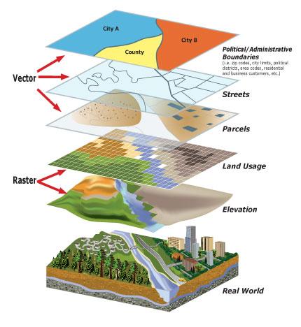
Vector vs raster data
- Vector data represents geographic features using points, lines, and polygons, while raster data uses a grid of cells to represent continuous surfaces or images
- Vector data is suitable for representing discrete features (roads, buildings), while raster data is ideal for continuous phenomena (elevation, temperature)
- Understanding the differences between vector and raster data is essential for selecting the appropriate data format and processing techniques for a given geospatial analysis task
Common geospatial file formats
- Shapefile is a popular vector data format that stores geometric and attribute information for geographic features
- GeoTIFF is a widely used raster format that embeds geospatial metadata within a TIFF file, allowing for georeferencing and spatial analysis
- GeoJSON is a lightweight, text-based format for encoding geographic features and their properties, commonly used in web mapping applications
- NetCDF is a format designed for storing multidimensional scientific data, including geospatial data with temporal and vertical dimensions
Open vs proprietary standards
- Open standards, such as those developed by the Open Geospatial Consortium (OGC), promote interoperability and data sharing by providing a common framework for geospatial data and services
- Proprietary standards, often associated with specific software vendors, may limit data exchange and integration with other systems
- Adopting open standards facilitates data integration and collaboration among different organizations and platforms
Data conversion and transformation
- Data conversion and transformation are essential processes in geospatial engineering that enable the integration of data from various sources and formats
- These processes involve manipulating and adapting geospatial data to ensure compatibility, consistency, and usability for a specific analysis or application
Coordinate system transformations
- Coordinate system transformations are necessary when integrating data from different spatial reference systems
- Transforming data from one coordinate system to another ensures that all datasets are in a common spatial framework, enabling accurate spatial analysis and overlay operations
- Common coordinate system transformations include converting between geographic (latitude/longitude) and projected coordinate systems (UTM, State Plane)
Data format conversions
- Data format conversions involve translating geospatial data from one file format to another to ensure compatibility with different software tools and systems
- Converting data between vector and raster formats may be necessary depending on the analysis requirements and the capabilities of the software being used
- Tools like GDAL (Geospatial Data Abstraction Library) and FME (Feature Manipulation Engine) facilitate data format conversions and enable the integration of data from various sources
Handling data quality issues
- Data quality issues, such as missing values, outliers, and inconsistencies, can hinder data integration and affect the accuracy of geospatial analysis
- Identifying and addressing data quality issues is crucial for ensuring the reliability and usability of integrated datasets
- Data cleaning techniques, such as filtering, interpolation, and error correction, can be applied to improve data quality and facilitate seamless integration
Spatial data infrastructures (SDIs)
- Spatial Data Infrastructures (SDIs) are frameworks that facilitate the discovery, access, and sharing of geospatial data and services across organizations and communities
- SDIs play a crucial role in promoting data integration and interoperability by providing a common platform for data providers and users to interact and collaborate
Components of an SDI
- An SDI typically consists of several key components, including geospatial data, metadata, standards, policies, and technologies
- Geospatial data is the foundation of an SDI, encompassing various datasets from different sources and themes (topography, land use, transportation)
- Metadata provides descriptive information about geospatial datasets, enabling users to discover, evaluate, and access relevant data
- Standards ensure interoperability and data compatibility across different systems and platforms
- Policies and institutional arrangements govern data sharing, access, and use within the SDI community
Role in facilitating data sharing
- SDIs facilitate data sharing by providing a centralized repository or distributed network of geospatial data and services
- Through SDIs, data providers can publish and share their datasets with a wider audience, while data users can discover and access relevant data for their specific needs
- SDIs promote collaboration and reduce duplication of efforts by enabling the reuse and integration of existing geospatial data
Examples of national and international SDIs
- The U.S. National Spatial Data Infrastructure (NSDI) is a collaborative effort to share geospatial data and services among federal, state, and local agencies
- The Infrastructure for Spatial Information in Europe (INSPIRE) is an initiative to create a harmonized and interoperable spatial data infrastructure across the European Union
- The Global Earth Observation System of Systems (GEOSS) is an international effort to integrate Earth observation data and services from various sources to support decision-making and research
Interoperability frameworks
- Interoperability frameworks provide a set of standards, specifications, and guidelines that enable the seamless exchange and integration of geospatial data and services across different systems and platforms
- These frameworks are essential for facilitating data integration and ensuring that geospatial data can be effectively shared and used by a wide range of stakeholders
Open Geospatial Consortium (OGC) standards
- The Open Geospatial Consortium (OGC) is an international organization that develops and maintains open standards for geospatial data and services
- OGC standards, such as Web Map Service (WMS), Web Feature Service (WFS), and Catalog Service for the Web (CSW), provide a common language for requesting, accessing, and exchanging geospatial data over the web
- Adopting OGC standards ensures interoperability and facilitates data integration across different platforms and software applications
Web services for geospatial data
- Web services, such as those based on OGC standards, enable the discovery, access, and manipulation of geospatial data over the internet
- Web Map Service (WMS) allows users to request and display georeferenced map images from multiple servers
- Web Feature Service (WFS) enables users to query, retrieve, and manipulate vector data over the web
- Web Coverage Service (WCS) provides access to raster data, such as satellite imagery and digital elevation models
Importance of metadata and cataloging
- Metadata is essential for describing the content, quality, and characteristics of geospatial datasets, enabling users to discover and evaluate the suitability of data for their specific needs
- Cataloging involves organizing and indexing metadata records to facilitate the discovery and access of geospatial data
- Well-structured metadata and efficient cataloging systems are crucial for enabling data integration and interoperability within an SDI or interoperability framework
Data fusion techniques
- Data fusion techniques involve combining data from multiple sources to create a more comprehensive, accurate, and reliable representation of the world
- These techniques are essential for integrating geospatial data from various sensors, platforms, and formats to support advanced spatial analysis and decision-making
Combining data from multiple sources
- Data fusion techniques enable the integration of data from various sources, such as remote sensing imagery, GPS data, and GIS databases
- Fusing data from multiple sources can provide a more complete picture of the study area, leveraging the strengths of each data source to overcome the limitations of individual datasets
- Example: Combining high-resolution satellite imagery with LiDAR data to create detailed 3D models of urban environments

Resolving spatial and temporal inconsistencies
- Data fusion techniques help resolve spatial and temporal inconsistencies that may arise when integrating data from different sources
- Spatial inconsistencies can occur due to differences in coordinate systems, resolution, or accuracy, while temporal inconsistencies may result from varying data collection times or update frequencies
- Techniques such as spatial interpolation, resampling, and temporal alignment can be used to harmonize data and ensure consistency
Ensuring data integrity and accuracy
- Data fusion processes must include mechanisms to ensure the integrity and accuracy of the integrated dataset
- Quality control measures, such as error detection and correction, data validation, and uncertainty assessment, are essential for maintaining the reliability of fused data
- Example: Applying machine learning algorithms to identify and remove outliers or inconsistencies in fused datasets
Real-world applications
- Data integration and interoperability play a crucial role in various real-world applications, enabling the effective use of geospatial data for decision-making, planning, and problem-solving
- These applications demonstrate the practical value of data integration and highlight the importance of developing robust interoperability frameworks and data fusion techniques
Urban planning and smart cities
- Integrating geospatial data from various sources, such as land use maps, transportation networks, and demographic data, supports informed urban planning decisions
- Smart city initiatives rely on the integration of real-time sensor data, GIS databases, and analytics platforms to optimize city services and improve the quality of life for residents
- Example: Integrating traffic data, public transit schedules, and pedestrian flow data to optimize transportation systems and reduce congestion in urban areas
Environmental monitoring and management
- Data integration is essential for effective environmental monitoring and management, enabling the analysis of complex interactions between natural and human systems
- Integrating remote sensing data, ground-based measurements, and ecological models supports the assessment of environmental health, biodiversity, and natural resource management
- Example: Combining satellite imagery, weather data, and hydrological models to monitor and predict water quality in lakes and rivers
Emergency response and disaster management
- Data integration plays a critical role in emergency response and disaster management, facilitating rapid situational awareness and informed decision-making
- Integrating real-time data from various sources, such as weather sensors, social media feeds, and geospatial databases, enables effective coordination and resource allocation during emergencies
- Example: Fusing satellite imagery, crowdsourced data, and infrastructure maps to assess damage and prioritize response efforts in the aftermath of a natural disaster
Future trends and challenges
- The field of geospatial engineering is constantly evolving, driven by technological advancements, increasing data volumes, and the growing demand for data-driven solutions
- Future trends and challenges in data integration and interoperability will shape the way geospatial data is collected, managed, and utilized in the coming years
Big data and cloud computing
- The exponential growth of geospatial data, fueled by the proliferation of sensors, mobile devices, and social media, presents both opportunities and challenges for data integration and analysis
- Cloud computing platforms and big data technologies offer scalable solutions for storing, processing, and analyzing massive volumes of geospatial data
- Developing efficient data integration pipelines and leveraging distributed computing frameworks will be essential for handling the complexity and velocity of big geospatial data
Internet of Things (IoT) and sensor networks
- The Internet of Things (IoT) and the deployment of dense sensor networks are generating vast amounts of real-time, location-based data
- Integrating IoT data with traditional geospatial datasets requires the development of new data fusion techniques and interoperability standards
- Challenges include ensuring data quality, managing data streams, and extracting meaningful insights from the deluge of sensor data
Artificial intelligence and machine learning
- Artificial intelligence (AI) and machine learning (ML) techniques are increasingly being applied to geospatial data integration and analysis
- AI and ML algorithms can automate data fusion processes, identify patterns and anomalies, and extract valuable insights from integrated datasets
- Developing robust AI and ML models that can handle the complexity and diversity of geospatial data will be a key challenge in the coming years
- Example: Applying deep learning algorithms to automatically classify land cover types from fused satellite imagery and LiDAR data