Metadata and data lineage are crucial components of geospatial engineering. They provide essential information about datasets, enabling users to understand, discover, and effectively utilize geospatial information. This topic explores the fundamentals, creation, management, and applications of metadata and data lineage in geospatial projects.
Understanding metadata and data lineage is vital for assessing data quality, trustworthiness, and fitness for purpose. This knowledge supports data sharing, interoperability, and long-term preservation, while also facilitating compliance with data governance and regulatory requirements in geospatial engineering projects.
Metadata fundamentals
- Metadata provides essential information about data, enabling users to understand, discover, and effectively utilize geospatial datasets
- Metadata is crucial for data sharing, interoperability, and long-term preservation in geospatial engineering projects
- Metadata helps users assess the quality, accuracy, and fitness for purpose of geospatial data
Importance of metadata
- Facilitates data discovery and access by providing descriptive information about datasets
- Enables users to evaluate data quality, reliability, and suitability for their specific needs
- Supports data interoperability by providing standardized information for data exchange and integration
- Ensures long-term data preservation by documenting data provenance, processing steps, and technical characteristics
Types of metadata
- Descriptive metadata: Provides information about the content and context of data (title, abstract, keywords, spatial extent)
- Structural metadata: Describes the internal structure and organization of data (file formats, data schemas, relationships between data elements)
- Administrative metadata: Contains information for data management and preservation (creation date, data owner, access rights, licensing)
Metadata standards
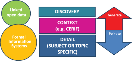
- Geospatial metadata standards ensure consistency and interoperability across different systems and organizations
- ISO 19115: International standard for geospatial metadata, defining a schema for describing geographic information and services
- FGDC Content Standard for Digital Geospatial Metadata (CSDGM): U.S. federal standard for geospatial metadata
- Dublin Core: A general-purpose metadata standard that can be applied to geospatial resources
Creating metadata
- Creating accurate and comprehensive metadata is essential for effective data management and utilization in geospatial engineering projects
- Metadata creation involves capturing relevant information about geospatial datasets throughout their lifecycle
Metadata creation process
- Identify the required metadata elements based on the chosen metadata standard
- Gather information about the dataset from various sources (data producers, documentation, data analysis)
- Enter metadata information into a metadata authoring tool or template
- Review and validate the metadata for completeness, accuracy, and compliance with standards
Metadata authoring tools
- Specialized software tools that facilitate the creation, editing, and management of geospatial metadata
- Examples of metadata authoring tools:
- ESRI ArcCatalog: Integrated with ArcGIS software for creating and managing geospatial metadata
- GeoNetwork: Open-source metadata catalog application for creating, editing, and publishing geospatial metadata
- EPA Metadata Editor (EME): A free tool developed by the U.S. Environmental Protection Agency for creating and validating geospatial metadata
Best practices for metadata creation
- Follow the chosen metadata standard and complete all mandatory and relevant optional elements
- Provide clear, concise, and accurate descriptions of the dataset and its characteristics
- Use controlled vocabularies and thesauri for consistent terminology and improved data discovery
- Include information about data quality, lineage, and limitations to help users assess the data's fitness for their purpose
- Regularly update metadata as the dataset evolves or new information becomes available
Metadata management
- Effective metadata management ensures that metadata remains accurate, up-to-date, and accessible throughout the geospatial data lifecycle
- Metadata management involves storing, maintaining, and updating metadata in a structured and organized manner
Metadata storage systems
- Metadata catalogs: Centralized repositories for storing and managing geospatial metadata records
- Examples of metadata catalogs:
- GeoNetwork: Open-source metadata catalog for storing, searching, and disseminating geospatial metadata
- CKAN: Open-source data management system that can be used to store and manage geospatial metadata
- Metadata can also be stored within the geospatial data files themselves (embedded metadata)
Metadata maintenance and updates
- Regularly review and update metadata to reflect changes in the dataset, such as updates to data content, quality, or access information
- Establish workflows and responsibilities for metadata maintenance to ensure consistency and timeliness of updates
- Use automated tools and scripts to facilitate metadata updates and synchronization across multiple systems
Metadata quality control
- Implement quality control processes to ensure metadata completeness, accuracy, and compliance with standards
- Use metadata validation tools to check for errors, inconsistencies, or missing information
- Conduct manual reviews of metadata records to assess their quality and usefulness for data discovery and understanding
- Establish metadata quality metrics and periodically assess metadata quality to identify areas for improvement
Metadata applications
- Metadata plays a crucial role in various aspects of geospatial data management, discovery, and use
- Effective utilization of metadata enhances the value and usability of geospatial data in different applications
Metadata for data discovery
- Metadata enables users to search for and discover relevant geospatial datasets based on specific criteria (spatial extent, keywords, data themes)
- Metadata catalogs and portals provide search interfaces that leverage metadata to help users find and access geospatial data
- Examples of geospatial data portals:
- Data.gov: U.S. government's open data portal, providing access to geospatial datasets and their metadata
- European Data Portal: Aggregates metadata from public sector data portals across European countries
Metadata for data interoperability
- Metadata supports data interoperability by providing standardized information about data formats, schemas, and content
- Metadata standards, such as ISO 19115 and OGC standards, promote data exchange and integration across different systems and platforms
- Metadata-driven data services, such as Web Feature Service (WFS) and Web Coverage Service (WCS), enable interoperable access to geospatial data
Metadata in geospatial data catalogs
- Geospatial data catalogs are centralized repositories that organize and manage metadata records for geospatial datasets
- Metadata catalogs facilitate data discovery, access, and sharing by providing a single point of access to metadata and data resources
- Examples of geospatial data catalogs:
- GeoNetwork: Open-source metadata catalog for managing and publishing geospatial metadata
- ESRI ArcGIS Online: Cloud-based platform for creating, managing, and sharing geospatial data and metadata
Data lineage concepts
- Data lineage is a crucial aspect of geospatial data management that tracks the origin, transformations, and dependencies of datasets
- Understanding data lineage is essential for assessing data quality, trustworthiness, and fitness for purpose in geospatial engineering projects
Definition of data lineage
- Data lineage refers to the historical record of a dataset's origin, processing steps, and transformations over time
- It captures the "lifecycle" of a dataset, from its initial creation through various stages of processing, analysis, and dissemination
- Data lineage provides a transparent and traceable account of how data has been manipulated and evolved
Importance of data lineage
- Helps users understand the source and reliability of geospatial data
- Enables assessment of data quality and identification of potential errors or biases introduced during data processing
- Supports reproducibility and validation of geospatial analyses and results
- Facilitates compliance with data governance and regulatory requirements
Data lineage vs data provenance
- Data lineage and data provenance are closely related concepts, but with some differences in focus and scope
- Data lineage emphasizes the sequence of processing steps and transformations applied to a dataset
- Data provenance encompasses a broader context, including information about data origin, ownership, and access rights
- Both lineage and provenance contribute to the overall understanding and trust in geospatial data
Data lineage capture
- Capturing data lineage involves recording and documenting the various steps, processes, and dependencies involved in the creation and management of geospatial datasets
- Effective lineage capture is essential for maintaining a complete and accurate record of a dataset's history and evolution
Methods for capturing data lineage
- Manual documentation: Maintaining records of data processing steps, transformations, and quality checks performed on datasets
- Automated capture: Using software tools and systems that automatically record data lineage information during data processing and analysis
- Workflow management systems: Integrating lineage capture into geospatial data workflows to track data transformations and dependencies
- Metadata standards: Incorporating lineage information into metadata records using standardized elements and schemas
Data lineage documentation
- Data lineage documentation should include information about:
- Data sources and origin
- Data processing steps and transformations
- Software tools and versions used
- Quality control and validation procedures
- Data dependencies and relationships
- Documentation can be in the form of text documents, diagrams, or structured metadata records
Challenges in data lineage capture
- Complexity of geospatial data workflows and processing pipelines
- Heterogeneity of data formats, tools, and systems used in geospatial data management
- Lack of standardization and interoperability in lineage documentation practices
- Balancing the level of detail and granularity in lineage capture with the associated costs and efforts
- Ensuring the completeness, accuracy, and consistency of captured lineage information
Data lineage representation
- Data lineage representation involves organizing and presenting lineage information in a structured and meaningful way
- Effective lineage representation enables users to understand and trace the history and dependencies of geospatial datasets
Data lineage models and frameworks
- Conceptual models that define the key elements, relationships, and semantics of data lineage information
- Examples of data lineage models and frameworks:
- Open Provenance Model (OPM): A general-purpose model for representing provenance information, including data lineage
- W3C PROV: A set of specifications and ontologies for representing and exchanging provenance information on the web
- ISO 19115-1:2014: Geospatial metadata standard that includes elements for capturing data lineage information
Visual representation of data lineage
- Graphical representations that depict the flow and dependencies of data through various processing stages
- Examples of visual lineage representations:
- Data flow diagrams: Illustrate the movement of data through a system or process, showing inputs, outputs, and transformations
- Directed acyclic graphs (DAGs): Represent data lineage as a graph, with nodes representing datasets and edges representing processing steps or dependencies
- Sankey diagrams: Visualize the flow and proportions of data through different stages or categories
Data lineage metadata standards
- Standardized metadata elements and schemas that incorporate data lineage information
- Examples of data lineage metadata standards:
- ISO 19115-1:2014: Geospatial metadata standard that includes elements for capturing data lineage information
- Provenance Ontology (PROV-O): An ontology for representing provenance information, including data lineage, using RDF and OWL
- Data Documentation Initiative (DDI): A metadata standard for describing social science data, including provenance and lineage information
Data lineage applications
- Data lineage has various applications in geospatial data management, quality assurance, and data governance
- Leveraging data lineage information can help organizations ensure data quality, compliance, and effective decision-making
Data lineage for data quality
- Data lineage helps assess the quality and reliability of geospatial datasets by providing information about their origin, processing, and transformations
- Lineage information can be used to identify potential sources of errors, inconsistencies, or biases in datasets
- By tracing data lineage, users can determine the appropriate level of trust and confidence in geospatial data for their specific applications
Data lineage for data governance
- Data lineage supports data governance by providing a transparent and auditable record of data management practices
- Lineage information helps organizations demonstrate compliance with data governance policies, standards, and regulations
- Data lineage can be used to establish accountability and track the responsible parties for data management decisions and actions
Data lineage in geospatial data workflows
- Integrating data lineage capture and representation into geospatial data workflows enables seamless tracking and documentation of data transformations
- Lineage-aware workflows can automate the generation of metadata, provenance, and quality information
- Data lineage can be used to optimize and streamline geospatial data workflows by identifying redundant or inefficient processing steps
Integrating metadata and data lineage
- Integrating metadata and data lineage information provides a comprehensive view of geospatial datasets, their characteristics, and their history
- Combining metadata and lineage enables users to make informed decisions about data quality, fitness for purpose, and trustworthiness
Benefits of integration
- Enhances data discovery and understanding by providing context about data origin, processing, and quality
- Supports data governance and compliance by documenting data management practices and responsibilities
- Facilitates data interoperability and reuse by providing standardized information about data structure, semantics, and dependencies
- Enables reproducibility and validation of geospatial analyses and results
Approaches to integration
- Embedding lineage information within metadata records using standardized elements and schemas
- Linking metadata records to external lineage documentation or provenance databases
- Developing integrated data management systems that capture and manage both metadata and lineage information
Tools for metadata and data lineage integration
- Metadata management systems that support the capture and storage of lineage information (e.g., GeoNetwork, CKAN)
- Workflow management systems that automatically capture and associate lineage information with metadata (e.g., Apache Airflow, Kepler)
- Data integration platforms that combine metadata and lineage management capabilities (e.g., Talend, Informatica)
Future trends and challenges
- The field of metadata and data lineage management is constantly evolving, driven by technological advancements and the increasing complexity of geospatial data ecosystems
- Future trends and challenges in this area will shape the way organizations manage, share, and utilize geospatial data
Emerging technologies for metadata and data lineage
- Machine learning and artificial intelligence techniques for automated metadata generation and lineage capture
- Blockchain technologies for secure and tamper-proof recording of data provenance and lineage
- Semantic web technologies for enhanced metadata interoperability and linked data management
- Big data and cloud computing platforms for scalable metadata and lineage management
Challenges in metadata and data lineage management
- Ensuring the quality, completeness, and consistency of metadata and lineage information across diverse data sources and systems
- Developing standardized and interoperable approaches for metadata and lineage representation and exchange
- Balancing the costs and benefits of detailed metadata and lineage capture with the associated resource requirements
- Addressing privacy and security concerns related to the sharing and management of metadata and lineage information
Research directions in metadata and data lineage
- Developing advanced algorithms and techniques for automated metadata generation and lineage capture
- Exploring the integration of metadata and lineage management with emerging technologies, such as IoT, edge computing, and digital twins
- Investigating the use of ontologies and knowledge graphs for enhanced metadata and lineage representation and reasoning
- Studying the human factors and organizational aspects of metadata and lineage management, including user adoption, governance, and best practices