Vertical datums and height systems
Vertical datums and height systems define how we measure "how high" something is. Without a consistent reference surface, elevation data from different sources can't be compared or combined. This topic covers the types of vertical datums, the different ways heights are defined, and how to transform between them.
Vertical datums
A vertical datum is a reference surface from which elevations are measured. Think of it as the agreed-upon "zero" for height. The choice of vertical datum depends on the project's geographic extent, accuracy needs, and what data sources you're working with.
Geoid as reference surface
The geoid is the equipotential surface of Earth's gravity field that most closely approximates mean sea level across the globe. "Equipotential" means gravity potential is the same at every point on the surface, so water at rest would naturally settle along it.
The geoid is not a smooth mathematical shape. It has bumps and dips caused by uneven mass distribution inside the Earth (denser rock pulls the surface closer, less dense material lets it sag). This makes the geoid a physically meaningful reference: heights measured from it reflect how water actually flows, which is why it matters for engineering and hydrology.
Tidal vs orthometric datums
- Tidal datums are defined by long-term sea level observations at tide gauges. They reflect the local mean sea level at a particular station, averaged over a specific epoch (e.g., the National Tidal Datum Epoch in the U.S. covers a 19-year cycle). Because ocean dynamics differ from place to place, tidal datums can vary significantly between coastal regions.
- Orthometric datums are based on the geoid and account for gravity field variations. They provide a more physically consistent reference that works across large areas, not just at the coast.
The practical difference: tidal datums are tied to a specific tide gauge and are inherently local, while orthometric datums aim for broader consistency by referencing the geoid.
Local vs global datums
Local vertical datums are built from a tide gauge (the origin point) plus a leveling network that propagates heights inland. Examples include NAVD 88 in North America and the Normaal Amsterdams Peil (NAP) in Europe. Each local datum has its own origin, so heights in one datum don't directly match heights in another.
Global vertical datums aim to provide a single, unified reference worldwide. The International Height Reference System (IHRS) is an example, defined by a specific gravity potential value ().
Offsets between local datums can be substantial. Converting between them requires datum transformations supported by accurate geoid models.
Height systems
A height system defines how you measure the distance from a point to the reference surface. Different systems have different physical meanings, and confusing them is a common source of error.
Ellipsoidal heights
Ellipsoidal height () is the distance measured along the ellipsoid normal from the reference ellipsoid to the point of interest. It's a purely geometric quantity with no connection to gravity.
GNSS receivers output ellipsoidal heights directly, which makes them easy to obtain. However, ellipsoidal heights don't tell you which way water flows. Two points with the same ellipsoidal height can actually be at different gravitational potentials, meaning water could flow "uphill" in ellipsoidal terms. That's why you can't use raw GNSS heights for drainage design without converting them.
Orthometric heights
Orthometric height () is the distance along the plumb line (the curved line that follows the direction of gravity) from the geoid to the point of interest. Because orthometric heights are referenced to the geoid, they are physically meaningful: water flows from higher to lower .
Orthometric heights are the standard in surveying, topographic mapping, and civil engineering. They require knowledge of both the ellipsoidal height and the geoid undulation to compute from GNSS data.
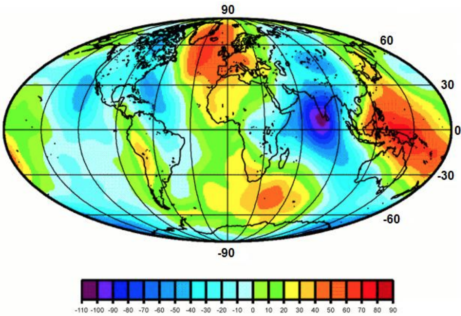
Geoid undulations
Geoid undulation (), also called geoid height, is the vertical separation between the geoid and the reference ellipsoid at a given location.
- : the geoid sits above the ellipsoid
- : the geoid sits below the ellipsoid
Globally, geoid undulations range from roughly m (south of India) to about m (around New Guinea). These variations reflect the uneven distribution of mass inside the Earth.
Height system transformations
The fundamental relationship connecting the three quantities is:
Where:
- = orthometric height
- = ellipsoidal height (from GNSS)
- = geoid undulation (from a geoid model)
To convert a GNSS-derived height to an orthometric height:
- Obtain the ellipsoidal height from your GNSS observation.
- Look up the geoid undulation at that location using a geoid model (e.g., EGM2008 globally, or GEOID18 for the U.S.).
- Subtract: .
The accuracy of this conversion depends directly on the quality of the geoid model. In well-surveyed regions, modern geoid models achieve centimeter-level accuracy. In remote areas with sparse gravity data, uncertainties can be much larger.
Gravity and the geoid
Earth's gravity field is what gives the geoid its shape. Understanding this connection is essential for accurate height determination.
Gravity potential
Gravity potential () is a scalar field representing the potential energy per unit mass at a point in Earth's gravity field. It combines gravitational attraction (from Earth's mass) and the centrifugal effect (from Earth's rotation).
Gravity potential varies with location because mass is distributed unevenly inside the Earth. A point above a dense ore body, for instance, will have a different potential than a point at the same geometric height above less dense sediment.
Equipotential surfaces
An equipotential surface is a surface where is constant everywhere. These surfaces are always perpendicular to the local gravity vector (the direction a plumb bob points).
Key properties:
- The geoid is one specific equipotential surface, chosen to approximate mean sea level.
- Equipotential surfaces are not parallel to each other. They converge slightly near the poles and diverge near the equator, and local mass anomalies distort them further.
- Water at rest conforms to an equipotential surface, which is why the geoid is such a natural reference for heights.
Geoid determination methods
There are three main approaches to determining the geoid:
Gravimetric methods use measurements of Earth's gravity field:
- Terrestrial gravity surveys at ground stations
- Airborne gravimetry for regional coverage
- Satellite missions like GRACE (gravity recovery) and GOCE (gravity gradients), which provide global gravity field models
Geometric methods combine GNSS and spirit leveling:
- Measure ellipsoidal height at a benchmark using GNSS.
- Measure orthometric height at the same benchmark using leveling tied to a vertical datum.
- Compute the geoid undulation: .
This gives you at discrete points, which can then be interpolated.
Combined methods integrate gravimetric and geometric data together. This is the standard modern approach, producing hybrid geoid models that leverage the global coverage of satellite data with the local accuracy of terrestrial measurements and GNSS/leveling.
Vertical datum realization
Realizing a vertical datum means physically establishing the reference surface through measurements, not just defining it mathematically.
Tide gauge measurements
Tide gauges record sea level over time at coastal stations. A long-term record (typically 19 years, covering a full lunar nodal cycle) is averaged to determine local mean sea level, which serves as the datum origin.
Tide gauge data is affected by:
- Ocean currents and atmospheric pressure variations
- Vertical land motion (subsidence or uplift at the gauge site), which can make sea level appear to change even when it hasn't
- Differences in sea surface topography between stations, meaning mean sea level is not actually at the same equipotential surface everywhere
Leveling networks
A leveling network is a web of benchmarks connected by precise spirit leveling. Starting from the tide gauge origin, height differences are measured between successive benchmarks and propagated across a region or country.
Leveling is extremely precise over short distances (sub-millimeter per km for first-order leveling), but errors accumulate over long lines. Systematic biases from unmodeled gravity effects can also creep in, which is why modern networks incorporate gravity observations.

Gravity observations
Gravity data serves two roles in datum realization:
- It defines the shape of the geoid, providing the reference surface.
- It corrects leveling measurements for the non-parallelism of equipotential surfaces (without gravity corrections, leveled heights are path-dependent).
Terrestrial, airborne, and satellite gravity data are combined to build the most complete picture of the gravity field.
Vertical datum unification
Different countries and regions have historically maintained their own vertical datums, each with a different origin and realization. Vertical datum unification brings these into a common framework so elevation data can be compared across borders.
Datum biases and offsets
When two vertical datums are compared, there is typically a constant (or slowly varying) offset between them. These offsets arise from:
- Different tide gauge origins with different mean sea level values
- Accumulated systematic errors in leveling networks
- Crustal deformation and sea level change since the datum was established
- Differences in how gravity corrections were applied
Offsets between national datums can range from a few centimeters to over a meter.
Least squares adjustment
Least squares adjustment is the standard mathematical tool for estimating datum offsets and combining heterogeneous data. It works by:
- Assembling observations from GNSS, leveling, and gravity at common points across datum boundaries.
- Setting up a system of observation equations that relate the measurements to unknown parameters (including datum offsets).
- Minimizing the sum of squared residuals, weighted by the uncertainty of each observation.
- Producing best-fit estimates of the datum offsets along with their uncertainties.
This approach is statistically rigorous and can handle large, complex networks with data of varying quality.
Geoid modeling in unification
A high-quality geoid model acts as the "translator" between datums. If you know the geoid undulation accurately everywhere, you can relate any local orthometric height to a global reference through the relationship.
Regional and global geoid models (e.g., EGM2008, regional models from national agencies) are continuously refined as new gravity data from satellite missions and terrestrial surveys becomes available. Better geoid models directly improve the accuracy of datum unification.
Applications in geospatial engineering
Topographic mapping
Vertical datums provide the elevation reference for contour lines, Digital Elevation Models (DEMs), and spot heights on topographic maps. If adjacent map sheets use different datums, elevation mismatches appear at the boundaries. Consistent datum usage across a mapping program prevents these discontinuities.
Floodplain management
Flood risk analysis depends heavily on accurate elevations. Base flood elevations, inundation boundaries, and flood insurance rate maps are all referenced to a specific vertical datum (NAVD 88 in the U.S., for example). Even small vertical errors, on the order of 10-20 cm, can significantly change which areas fall inside a mapped floodplain.
Infrastructure design
Roads, bridges, pipelines, and drainage systems all require precise elevation control. Vertical datum inconsistencies between different survey datasets on the same project can lead to drainage that flows the wrong way, insufficient bridge clearance, or misaligned utility connections. These errors are expensive to fix after construction.
Geodetic surveying considerations
When planning a survey, you need to decide on a vertical datum early and document it in your metadata. Key factors to consider:
- Project location and extent: Local datums may suffice for small projects; larger projects may need a global or national datum.
- Accuracy requirements: High-precision work demands careful geoid modeling and may require local GNSS/leveling calibration.
- Compatibility: If your data will be combined with existing datasets, use the same datum or plan for transformations.
- Documentation: Always record the datum, epoch, and geoid model used. Future users of your data will need this information to use it correctly.