Drainage basin components and characteristics
Drainage basin morphology describes the shape, structure, and spatial organization of the land area that funnels water into a river system. Understanding how basins evolve over time helps explain why landscapes look the way they do, and why rivers behave differently in different settings. This topic ties together tectonics, climate, rock type, and erosion into a unified framework for reading landscapes.
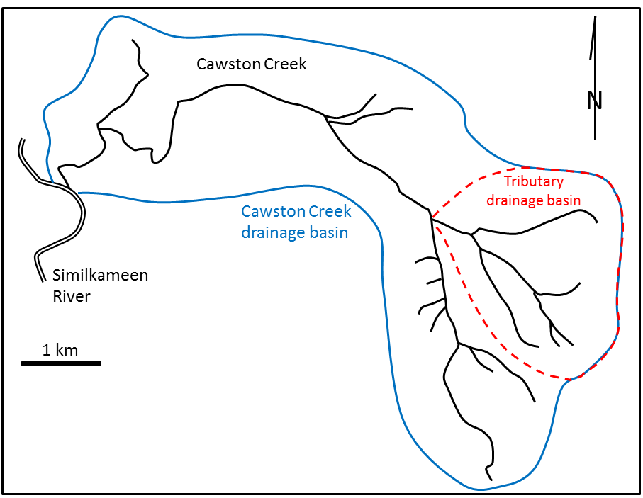
Watershed structure and boundaries
A drainage basin (also called a watershed or catchment) is the entire land area that contributes water to a specific stream or river system. Its main components are:
- Drainage divide: the topographic boundary that separates adjacent basins, running along the highest points of land between them
- Tributaries: smaller streams feeding into the main channel
- Main channel: the primary river carrying flow toward the outlet
- Floodplain: the low-lying area adjacent to the channel that gets inundated during high flows
- Outlet: the point where water exits the basin
Stream order classifies segments by their position in the network. First-order streams are the smallest unbranched headwater tributaries. When two first-order streams join, they form a second-order stream, and so on. This system (the Strahler method) gives you a quick sense of network complexity.
Drainage density is the total stream channel length divided by the basin area. A high drainage density means the landscape is heavily dissected with many channels per unit area, which typically corresponds to impermeable substrates, sparse vegetation, or high rainfall intensity. Low drainage density suggests permeable rock or thick soil that absorbs runoff before it concentrates into channels.
Basin shape and drainage patterns
Basin shape affects how quickly runoff concentrates at the outlet. Two common metrics:
- Circularity ratio: compares basin area to the area of a circle with the same perimeter. Values closer to 1.0 mean a more circular basin.
- Elongation ratio: compares basin diameter to the length of the longest flow path.
Circular basins tend to produce sharper, higher flood peaks because runoff from all parts of the basin arrives at the outlet around the same time. Elongated basins spread that arrival out, producing a lower, broader hydrograph.
Drainage patterns are diagnostic of the underlying geology:
- Dendritic: a tree-like branching network that develops on uniform, horizontally bedded rocks (e.g., flat-lying sandstone or shale). This is the most common pattern.
- Trellis: parallel main streams with short tributaries joining at near-right angles, controlled by alternating resistant and weak rock layers in folded terrain (e.g., the Appalachian Valley and Ridge Province).
- Radial: streams flowing outward from a central topographic high, like a volcanic cone (e.g., Mount Rainier).
- Rectangular: similar to dendritic but with right-angle bends controlled by joint sets or fault patterns in the bedrock.
Recognizing these patterns on a map or aerial image gives you direct insight into the geologic structure beneath the surface.
Factors influencing drainage basin morphology
Geological influences
Lithology (rock type) is one of the strongest controls on basin form. Resistant rocks like granite erode slowly, producing steep terrain and narrow valleys. Weaker rocks like shale erode more readily, forming gentler slopes and wider valleys. Permeability matters too: sandstone absorbs water and reduces surface runoff, while clay-rich rocks shed water and promote channel development.
Structural geology steers where channels go. Faults create linear valleys and abrupt changes in channel direction. Joints and bedding planes act as planes of weakness that erosion preferentially exploits. That's why rectangular drainage patterns develop in heavily jointed rock.
Tectonic activity changes the rules at a regional scale. Uplift steepens gradients and accelerates erosion, sometimes causing river capture (where one stream diverts flow from an adjacent basin). Subsidence can flatten gradients, leading to ponding, wetland development, or sediment accumulation.
Environmental and anthropogenic factors
Climate sets the baseline for how much water and energy are available to do geomorphic work:
- Arid regions develop sparse, ephemeral drainage networks with channels that only flow during and shortly after storms.
- Humid regions support dense, perennial stream systems with well-connected networks.
Vegetation cover stabilizes soil and intercepts rainfall. Forested basins generally have lower erosion rates and more stable channels. Remove that vegetation through fire, logging, or land-use change, and erosion rates can spike dramatically.
Human activities modify basin morphology on timescales much shorter than natural processes:
- Urbanization replaces permeable soil with impervious surfaces (roads, roofs), increasing runoff volume and peak discharge while reducing infiltration.
- Agriculture exposes bare soil to raindrop impact and overland flow, accelerating erosion and delivering sediment to channels.
- Dam construction traps sediment upstream, starving downstream reaches of their sediment supply and often causing channel incision below the dam.
Legacy effects and long-term evolution
Present-day basin morphology often reflects events that happened thousands or millions of years ago. Glacial valleys carved during the Pleistocene persist as U-shaped troughs in the Alps and Rockies. Ancient lake beds, like the Bonneville Salt Flats in Utah, form flat basin floors long after the lakes drained.
Tectonic history establishes the large-scale framework. Rift valleys create elongated basins (East African Rift). Mountain-building events set up major drainage divides, like the Continental Divide in North America, which separates Pacific-draining from Atlantic-draining rivers.
Relict landforms provide clues to past conditions:
- Wind gaps are dry notches in ridgelines that mark where streams once flowed before being captured or diverted (common in the Appalachians).
- Underfit streams occupy valleys far too large for their current discharge, suggesting the valley was carved by a much larger flow, often glacial meltwater (e.g., the Thames River in the UK).
Stages of drainage basin evolution
Youth stage characteristics
William Morris Davis proposed the geomorphic cycle (also called the cycle of erosion) in the late 1800s, describing landscape evolution through three stages: youth, maturity, and old age. While modern geomorphology has moved beyond this as a strict model, it remains a useful descriptive framework.
The youth stage is marked by:
- Steep stream gradients and rapid downcutting
- V-shaped valleys with little to no floodplain development
- Waterfalls and rapids where streams cross resistant rock layers
- Active headward erosion expanding the drainage network into undissected uplands
- Sediment production that often exceeds the stream's capacity to transport it
Recently uplifted terrain, like the California Coast Ranges, displays many of these characteristics.

Maturity and old age stages
In the maturity stage, the basin transitions from vertical incision to lateral erosion:
- Valleys widen and floodplains develop along the main channel
- Stream profiles approach a graded condition, where slope adjusts so the stream can just transport its sediment load
- Tributaries become well-integrated into the main network
- Waterfalls and rapids become less common as the profile smooths out
The old age stage represents a low-energy landscape:
- Low relief with broad, meandering streams
- Extensive floodplains dotted with oxbow lakes
- Occasional residual hills (called monadnocks in Davis's terminology) rising above the otherwise flat surface
- Sluggish drainage with potential for marsh and swamp development
- Parts of the Amazon Basin illustrate this stage
Dynamic processes and equilibrium concepts
Several processes complicate the neat progression of Davis's cycle:
Stream capture (piracy) occurs when a more erosively aggressive stream breaches a drainage divide and diverts flow from an adjacent basin. This creates an elbow of capture (a sharp bend in the capturing stream) and a wind gap (the abandoned valley of the captured stream). A classic example is the River Severn capturing headwaters that formerly drained to the River Thames.
Knickpoints are abrupt changes in stream gradient, often visible as waterfalls or steep reaches. They can result from:
- A drop in base level (e.g., sea-level fall)
- Tectonic uplift
- A transition from weak to resistant rock
Knickpoints migrate upstream over time as erosion works on them, and tracking their positions can reveal the history of base-level or tectonic changes in a basin.
Dynamic equilibrium is the modern alternative to Davis's predetermined cycle. Rather than marching inevitably from youth to old age, basins maintain a quasi-steady state where erosion and deposition roughly balance over time. External perturbations (uplift, climate shifts, base-level changes) push the system out of equilibrium, and it adjusts toward a new balance. This framework better accounts for the fact that basins can be "rejuvenated" by tectonic uplift rather than simply aging in one direction.
Tectonics, climate, and lithology in drainage basin morphology
Tectonic influences on basin evolution
Tectonic uplift rejuvenates drainage basins by steepening gradients and increasing erosion rates. When uplift is slow relative to river incision, rivers can maintain their course across rising structures, creating antecedent drainage. The Colorado River cutting through the rising Colorado Plateau to form the Grand Canyon is a commonly cited example.
Fault activity directly creates and modifies basins. The Basin and Range Province of the western U.S. consists of fault-block mountains separated by down-dropped basins, each with its own internal drainage system. Fault lines also guide stream channels, producing linear valley segments.
Quantitative tools for detecting tectonic influence include:
- Channel steepness index (): higher values suggest faster uplift rates
- Channel concavity (): deviations from expected concavity profiles can indicate tectonic perturbation
- Knickpoint migration rates: faster migration often correlates with more active tectonics
Climate and extreme events
Climate change reshapes basins by altering precipitation, vegetation, and weathering regimes. Increased rainfall can accelerate incision; decreased rainfall can cause channels to aggrade as reduced flows lose transport capacity.
Extreme events leave lasting marks on basin morphology:
- Glaciations carve U-shaped valleys, cirques, and hanging valleys (Yosemite Valley is a textbook example).
- Catastrophic floods (like glacial outburst floods) can scour entirely new channel paths.
- Intense rainfall events trigger mass wasting (landslides, debris flows) and channel avulsions (sudden shifts in channel position).
Basin morphology also serves as a paleoclimate archive. River terraces form when a stream incises into its own floodplain, often in response to climate-driven changes in discharge or sediment supply. A sequence of terraces records multiple episodes of incision. Alluvial fans at mountain fronts reflect episodic sediment delivery under arid to semi-arid conditions.
Lithological controls and interactions
Differential erosion driven by rock type is visible everywhere in fluvial landscapes. Resistant layers form ridges, waterfalls, and knickpoints. Weaker layers erode into valleys and lowlands. In layered sedimentary sequences, this contrast creates the stepped topography and trellis drainage patterns seen in fold belts.
Rock type also controls drainage density. Impermeable rocks (like unfractured shale) generate more surface runoff and support denser channel networks. Soluble rocks like limestone can develop karst drainage, where water flows underground through dissolved conduits rather than in surface channels, resulting in very low surface drainage density.
The interaction among tectonics, climate, and lithology creates complex feedbacks. Uplift exposes different rock types to surface erosion. Climate determines the intensity and style of weathering those rocks experience. The resulting erosion products influence channel form and sediment transport downstream.
Hypsometric analysis is a useful tool for reading these interactions. A basin's hypsometric curve plots the proportion of area above each elevation. A convex curve indicates a youthful, tectonically active basin where much of the original surface remains. A concave curve suggests a mature basin where erosion has removed most of the high-standing terrain. An S-shaped curve is typical of basins in an intermediate state.