Tectonic geomorphology explores how Earth's surface changes due to tectonic forces and erosion. It's crucial for understanding landscape evolution, revealing how mountains form, rivers change course, and landforms develop over time.
Active faulting plays a key role in shaping topography. Fault scarps, offset streams, and unique drainage patterns are telltale signs of tectonic activity. These features help geologists piece together Earth's dynamic history and predict future changes.
Tectonic Geomorphology: Landscape Evolution
Defining Tectonic Geomorphology
Tectonic geomorphology studies the interaction between tectonic processes (forces from within the Earth) and surface processes (erosion, weathering, deposition) that together shape landscapes over time. It pulls from structural geology, geophysics, and geomorphology to build a complete picture of how tectonics drive landform development.
Why does this matter? By analyzing geomorphic features and their spatial relationships, you can reconstruct past tectonic events and estimate rates of crustal deformation. That's directly useful for assessing seismic hazards and predicting how landscapes will continue to evolve.
The field relies on several key techniques to quantify landscape change:
- Remote sensing for mapping landforms and detecting surface deformation over large areas
- Field observations for ground-truthing and detailed structural measurements
- Geochronology (e.g., cosmogenic nuclide dating, luminescence dating) for determining when surfaces were created or modified
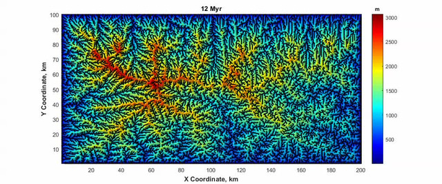
- Numerical modeling for simulating landscape evolution under different tectonic and erosional scenarios
At its core, tectonic geomorphology tracks the competition between endogenic processes (tectonic uplift, faulting, volcanism) that build topography and exogenic processes (weathering, erosion, sediment transport) that wear it down.
Significance in Landscape Evolution
- Reveals how internal (tectonic) and external (climatic/erosional) Earth processes interact to produce the landscapes we see
- Helps identify areas of active tectonism and potential seismic hazards by recognizing geomorphic signatures of recent faulting
- Enables reconstruction of past tectonic events, such as the uplift history of mountain ranges like the Himalayas or the Alps
- Provides insights into sediment transport and deposition in tectonically active regions, which matters for understanding basin stratigraphy
- Supports natural resource exploration by revealing structural controls on mineral deposits and groundwater flow
- Informs land-use planning and infrastructure development in tectonically active areas, where fault-related hazards must be accounted for
Active Faulting Indicators
Topographic Features
Several distinctive landforms signal active faulting. Recognizing these in the field or on imagery is a core skill in tectonic geomorphology.
Fault scarps are steep, linear breaks in topography created by vertical displacement along a fault plane. They indicate recent or ongoing tectonic activity. The height and morphology of a scarp can reveal the fault's slip history: a tall, sharp scarp suggests recent large-magnitude displacement, while a degraded, rounded scarp indicates an older event modified by erosion.
Triangular facets are triangular-shaped hillslopes that develop at the base of mountain fronts due to normal faulting. As the footwall is uplifted and the hanging wall drops, erosion carves V-shaped valleys into the escarpment, leaving triangular remnants between them. Their size and steepness relate to the balance between fault activity rate and erosion rate.
Shutter ridges are elongated hills produced by lateral movement along strike-slip faults. A ridge on one side of the fault slides across and blocks or deflects drainage on the other side. The Carrizo Plain along the San Andreas Fault in California has classic examples.
Pressure ridges and sag ponds form along strike-slip faults where the fault trace bends or steps:
- Pressure ridges develop at restraining bends where compression uplifts the surface
- Sag ponds develop at releasing bends where extension creates depressions that often fill with water or sediment
Drainage System Indicators
Rivers and streams are sensitive recorders of tectonic activity because they respond to changes in gradient, base level, and rock resistance.
Offset streams show abrupt lateral shifts where they cross an active fault. Wallace Creek along the San Andreas Fault is a textbook example: the stream channel is displaced roughly 130 meters to the right, recording cumulative strike-slip motion.
Knickpoints are abrupt changes in a river's longitudinal profile caused by tectonic uplift. When a fault uplifts a block, the river steepens locally, and this steep reach migrates upstream over time as the river erodes through the uplifted zone.
Linear valleys and aligned drainage often trace active faults because erosion preferentially exploits the fractured, weakened rock along fault zones.
Wind gaps and water gaps develop where rivers interact with uplifting terrain:
- A water gap is an active river course that has maintained its path by cutting through a rising structure (e.g., the Delaware Water Gap through the Appalachian ridges)
- A wind gap is an abandoned water gap where the river was defeated by uplift or captured by another stream, leaving a dry notch in the ridge
Active Faulting: Shaping Topography
Regional Landform Development
Active faulting creates and maintains topographic relief by offsetting rock units and generating zones of weakness that erosion exploits. Over geologic time, fault systems control the development of major landforms:
- Mountain ranges like the Sierra Nevada, uplifted along a major normal fault on its eastern side
- Extensional basins in the Basin and Range Province, where alternating horsts and grabens create parallel mountain ranges separated by flat valleys
- Rift valleys like the East African Rift, where continental crust is being pulled apart
The morphology of mountainous terrain reflects the ongoing competition between fault-driven uplift and erosion. Where uplift outpaces erosion, relief grows. Where erosion dominates, mountains are worn down.
Fault activity also drives sedimentary basin formation through subsidence of the hanging wall. The San Joaquin Valley in California, for instance, is a tectonically controlled basin where subsidence has created accommodation space for thick sedimentary sequences, directly shaping the regional landscape.
Drainage Network Influence
Active faulting reshapes drainage networks in several ways:
- Creating topographic barriers that block or redirect rivers
- Changing base levels, which forces rivers to incise or aggrade
- Altering channel gradients, triggering knickpoint migration
Faults can cause river capture (also called stream piracy), where one river system steals flow from another due to tectonic tilting or barrier creation. The Gunnison River capture in Colorado is a well-known example.
Localized zones of high erosion along faults produce distinctive features like wind gaps and water gaps. In fault-bounded basins, tectonic activity controls where sediment accumulates and how thick deposits become. In some cases, faulting causes drainage reversals or creates endorheic basins (internally drained basins with no outlet to the ocean), common in tectonically active continental interiors.
Fault Type, Slip Rate, and Landforms
Fault Types and Associated Landforms
Different fault types produce different landscape signatures:
- Normal faults create asymmetric mountain ranges with a steep, faulted escarpment on one side and a gentler dip slope on the other. Tilted fault blocks are characteristic. The Wasatch Range in Utah is a classic example, with its dramatic western escarpment rising above the Salt Lake Valley.
- Reverse (thrust) faults tend to produce more symmetrical mountain ranges with thrust-related folding. The San Gabriel Mountains in southern California are bounded by reverse faults that accommodate compression at a bend in the San Andreas system.
- Strike-slip faults generate a distinctive suite of features: offset drainages, shutter ridges, and pull-apart basins that form at releasing stepovers. The Dead Sea Basin is a pull-apart basin along the Dead Sea Transform fault. The degree of offset on any feature relates to the fault's slip rate and the age of the feature.
Slip Rate and Landscape Evolution
The slip rate of a fault (how fast the two sides move relative to each other) controls how rapidly the landscape changes. Higher slip rates generally produce more pronounced, rapidly evolving geomorphic features.
The key relationship to understand is the balance between fault slip rate and erosion rate:
- When slip rate exceeds erosion rate, tectonic landforms accumulate and relief grows
- When erosion rate exceeds slip rate, tectonic features are degraded and eventually erased
- The persistence of any fault-related landform depends on this balance
Variations in slip rate along the length of a single fault create differential uplift or subsidence. This produces complex topographic patterns and influences how drainage networks develop along the fault zone.
Fault slip rates can be estimated by measuring the displacement of geomorphic markers (offset terraces, alluvial fans, stream channels) and dating them with techniques like cosmogenic nuclide exposure dating or radiocarbon dating. These measurements allow you to quantify long-term rates of landscape evolution and compare them across different tectonic settings.