Plate Tectonics and Landscape Development
Plate tectonics shapes Earth's surface through massive forces that create mountains, valleys, and ocean basins. This process drives landscape evolution by influencing erosion, sedimentation, and climate patterns over millions of years.
Understanding plate tectonics is key to grasping how landscapes form and change. It explains why mountains rise, continents drift, and earthquakes occur, connecting Earth's deep interior to the ground beneath your feet.
Plate Tectonics and Earth's Surface
Fundamentals of Plate Tectonics
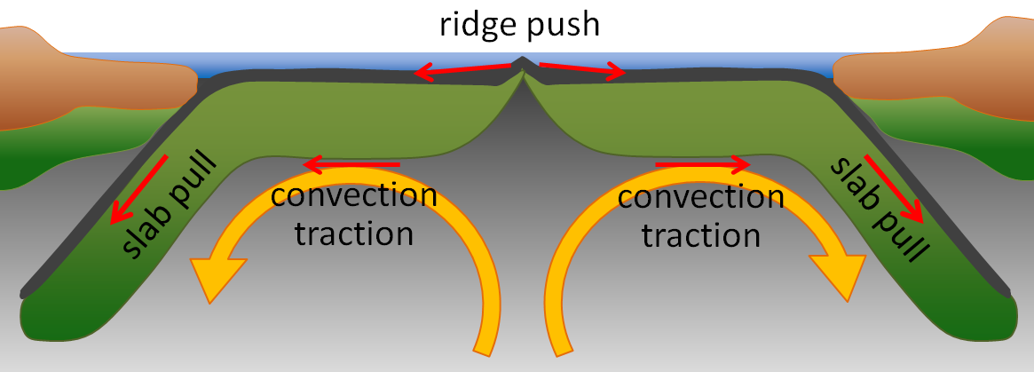
Plate tectonics is the unifying theory of geology. It explains large-scale motions of Earth's lithosphere, the rigid outer shell made up of the crust and uppermost mantle. These motions are driven by mantle convection currents, where heat from Earth's interior causes slow circulation in the mantle below.
The lithosphere is divided into several tectonic plates that move relative to one another. These movements create, destroy, and deform Earth's crust over millions of years. The Wilson Cycle describes how supercontinents (like Pangea, ~335–200 Ma) assemble and then break apart, repeatedly reshaping the configuration of continents and oceans.
Three main types of plate boundaries produce distinct patterns of crustal deformation:
- Divergent boundaries — plates move apart
- Convergent boundaries — plates collide
- Transform boundaries — plates slide laterally past each other
Global Impacts of Plate Tectonics
Plate tectonics doesn't just build mountains. It influences global climate patterns by altering:
- Ocean currents (e.g., the Gulf Stream, which depends on the geometry of the Atlantic basin)
- Atmospheric circulation (e.g., the Indian monsoon, intensified by Himalayan uplift)
- Distribution of land masses, which shifts as continents drift to different latitudes
Tectonic activity also controls where you find earthquakes (concentrated along the Ring of Fire), volcanoes (both at plate margins and at hotspots like Hawaii), and mineral resources (e.g., porphyry copper deposits at subduction zones).
The surface topography you see at any given time reflects a dynamic equilibrium between tectonic uplift building relief and erosional processes wearing it down.
Plate tectonics also plays a role in the global carbon cycle:
- Volcanic outgassing releases into the atmosphere
- Subduction carries carbonate sediments back into the mantle
- Mountain building exposes fresh rock, increasing chemical weathering rates that draw down atmospheric
Plate Boundaries and Landforms
Divergent Boundaries
At divergent boundaries, plates pull apart and new crust forms in the gap. In the oceans, this process is called seafloor spreading, and it builds mid-ocean ridges like the Mid-Atlantic Ridge, which is a continuous underwater mountain chain running the length of the Atlantic.
On continents, divergent forces produce rift valleys. The East African Rift System is a classic example: the African plate is slowly splitting, creating a series of deep valleys, volcanic centers, and elongated lakes. If rifting continues long enough, a new ocean basin forms. The Red Sea represents a rift that has already progressed to this stage.
Divergent boundaries are characterized by:
- Shallow earthquakes (brittle crust is thin here)
- Basaltic volcanism (partial melting of the rising mantle)
- Thin lithosphere and high heat flow
Convergent Boundaries
Convergent boundaries produce some of Earth's most dramatic topography. The specific landforms depend on what type of crust is involved in the collision.
Oceanic-oceanic convergence: One oceanic plate subducts beneath the other, creating a deep ocean trench (the Mariana Trench reaches ~11 km depth) and a curved chain of volcanic islands called an island arc (e.g., the Aleutian Islands).
Oceanic-continental convergence: The denser oceanic plate subducts beneath the continent. This builds coastal mountain ranges with active volcanism, like the Andes. Forearc basins form between the trench and the volcanic arc, while backarc basins can develop behind it.
Continental-continental collision: Neither plate subducts easily because continental crust is too buoyant. Instead, the crust crumples and thickens, producing massive fold-and-thrust belt mountain ranges. The Himalayas and Alps formed this way. The Tibetan Plateau, with an average elevation above 4,500 m, is a product of the extreme crustal thickening from the ongoing India-Eurasia collision.
Transform Boundaries
Transform boundaries involve lateral sliding along strike-slip faults. They don't typically build large mountain ranges, but they do create distinctive landforms:
- Linear valleys along the fault trace
- Offset streams where drainage is displaced by fault movement
- Sag ponds that form in small depressions along the fault zone
- Pull-apart basins where the fault geometry creates local extension (the Dead Sea sits in one of these, ~430 m below sea level)
The San Andreas Fault in California is the most well-known example, producing a complex zone of deformed topography and shallow but sometimes powerful earthquakes.
Plate Tectonics and Geomorphic Features
Mountain Building and Orogenesis
Orogenesis refers to the process of mountain building. Plate tectonics drives it through three main mechanisms:
- Compression at convergent boundaries — crustal shortening folds and faults rock into mountain belts
- Uplift of crustal blocks — large-scale vertical movements raise terrain
- Volcanic activity at subduction zones — magma generated by the descending plate builds volcanic peaks
Continental collisions produce fold-and-thrust belts with intense deformation and metamorphism of crustal rocks. These collisions also create foreland basins on the side facing the approaching plate (where eroded sediment accumulates) and hinterland basins behind the mountain belt.
Subduction-related volcanism creates linear chains of volcanoes. On continents, these are continental volcanic arcs (the Cascade Range, with peaks like Mt. Rainier and Mt. St. Helens). In the ocean, they form island arcs (the Mariana Islands).
Rift Valleys and Extensional Features
Rift valleys form where extensional forces stretch and thin the lithosphere. As the crust pulls apart, blocks of rock drop down along normal faults, creating elongated depressions called grabens.
These rift zones are characterized by:
- Elevated heat flow and volcanism (magma rises as the crust thins)
- Development of deep lake systems in the down-dropped blocks (Lake Tanganyika in the East African Rift is over 1,470 m deep)
- Thick accumulations of sediment in the rift basin
If rifting eventually stops, the thinned crust cools and subsides, evolving into a passive continental margin. The Atlantic coast of North America is a good example: it was once an active rift zone when the Atlantic Ocean first opened, but now it's a quiet, sediment-covered margin.
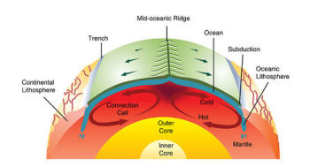
Plate Tectonics and Sedimentary Basins
Tectonic setting controls where sedimentary basins form, how fast they subside, and what kinds of sediment fill them. This matters for understanding landscape development and also for locating hydrocarbon resources.
Key types of tectonically controlled basins:
- Foreland basins — form adjacent to mountain belts due to the weight of the mountains flexing the crust downward (e.g., the Western Interior Seaway, a shallow sea that once covered central North America during the Cretaceous)
- Rift basins — form in extensional settings where the crust is pulling apart (e.g., the North Sea basin)
- Pull-apart basins — form at releasing bends along transform faults (e.g., the Salton Sea area in southern California)
Each basin type has distinct sedimentation patterns and subsidence rates that influence the resulting landscape.
Plate Motions and Landscape Evolution
Drainage Pattern Development
Tectonic activity shapes continental-scale drainage divides and river systems. When mountain ranges are uplifted, they reorganize where water flows, sometimes dramatically.
Uplift can lead to:
- Reorganization of drainage networks as new topographic barriers redirect rivers
- River capture events, where one stream erodes headward and "captures" the flow of another (e.g., the Wind River system in Wyoming)
- Antecedent streams that maintain their course by cutting down through rising rock. The Colorado River carving through the uplifting Colorado Plateau to form the Grand Canyon is a classic example.
Changes in base level (the lowest elevation to which a river can erode) also reshape landscapes. Base level shifts when sea level rises or falls due to plate motions, or when tectonic uplift or subsidence raises or lowers coastal regions.
Long-term Landscape Changes
Over tens to hundreds of millions of years, the formation and breakup of supercontinents drives sweeping changes:
- Global ocean circulation patterns shift as seaways open and close (affecting thermohaline circulation and heat transport)
- Continental weathering rates change as land masses move to different climate zones
Isostatic adjustment is another important long-term process. The lithosphere "floats" on the denser asthenosphere below. When mountains erode and lose mass, the crust slowly rebounds upward. When sediment accumulates in a basin, the crust subsides. These adjustments modify regional topography and drainage patterns over millions of years.
Tectonic subsidence also creates accommodation space, the room available for sediment to accumulate. This controls the development of large river deltas like the Mississippi Delta, where ongoing subsidence allows thick sediment sequences to build up.
Tectonic-Climate Interactions
The relationship between tectonics and climate is one of the most important feedback loops in Earth surface processes.
Orographic effects: When plate tectonics uplifts a mountain range, it forces moist air upward on the windward side, causing heavy orographic precipitation. The leeward side receives much less moisture, creating a rain shadow. The contrast between the wet western slopes and dry eastern side of the Cascades or the Andes illustrates this clearly.
Weathering feedbacks: Mountain building exposes fresh silicate rock to the atmosphere. Silicate weathering consumes atmospheric , so periods of major mountain building (like the Himalayan orogeny) may contribute to long-term global cooling. This is a negative feedback: tectonics builds mountains, weathering draws down , climate cools, and glacial erosion then modifies the uplifted landscape.
Ocean circulation: As plates move and continents shift position, ocean current patterns change. The opening of Drake Passage (~34 Ma) allowed the Antarctic Circumpolar Current to form, thermally isolating Antarctica and contributing to its glaciation. Closer to the present, the geometry of the Atlantic basin sustains the Gulf Stream, which redistributes heat northward and influences European climate. Coastal upwelling zones, like the one driven by the Peru Current off South America, are also tied to the configuration of coastlines set by plate tectonics.