Types of Clouds
4 min read•december 9, 2021
Sitara H
Sitara H
Types of Clouds
How Clouds Form
Not all clouds are created equal. Clouds have different names based on their shape and height above the Earth. We can also categorize them into other groups in two ways: either by height or by their unique characteristics. ⛅
Cloud Group + Height | Cloud Types |
High Clouds: 5-13 km above Earth’s surface | Cirrus, Cirrocumulus, Cirrostratus |
Middle Clouds: 2-7 km | Altocumulus, Altostratus |
Low Clouds: Surface-2 km | Stratus, Stratocumulus, Nimbostratus |
Clouds with Vertical Growth: clouds that grow upwards, instead of spreading out | Cumulus, Cumulonimbus |
Unusual Clouds: Clouds that form in unique ways, not grouped by height | Lenticular |
High-Level Clouds
1 Cirrus
Cirrus clouds are one of the most common cloud types and can be seen at any time throughout the year. They have a thin and wispy appearance due to the ice crystals that make them. The level of separation between these crystals determines how transparent the cloud is. 💎
They also stand out because they are often seen in different colors as the sun rises and sets; they stay lit much longer than other clouds. Cirrus clouds are located far above us, 20,000 to 40,000 feet near their base. They often form in advance of a warm front when clouds meet at high levels. ☝
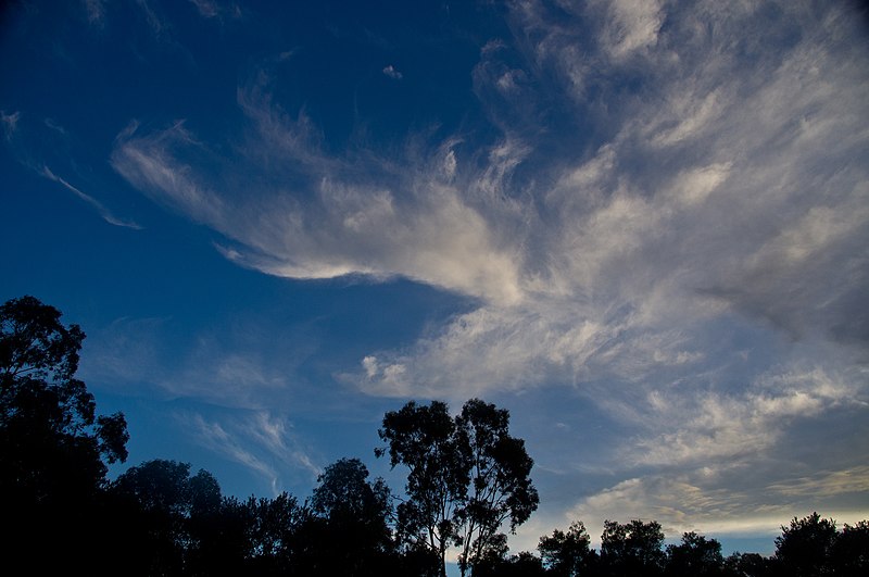
Image courtesy of Wikimedia
2 Cirrocumulus
These clouds form with small, white fluffy patterns and spread out for miles in the sky. They can sometimes have a greyish color that gives them the nickname “mackerel skies.” 🐟
It’s important to remember that cirrocumulus clouds never generate rainfall (but they can still indicate incoming cold weather), nor do they ever interact with other types of clouds to form larger cloud structures. 🌂🙅♂️
3 Cirrostratus
They have a sheet-like greyish and a pretty translucent appearance. Purely white cirrostratus clouds signify stored moisture, which indicates the presence of a warm frontal system. 🔥
Middle-Level Clouds
1 Altocumulus
Altocumulus clouds form at a lower altitude, so water droplets make up a higher percentage of their makeup. When they appear with other types of clouds simultaneously, storms typically follow with light to moderate rainfall. ❗
They are pretty common in most parts of the world! 🌎
2 Altostratus
These clouds are often spread over huge areas and are strongly linked to light rainfall and snowfall. They are also known as "boring clouds" because they are uniformly gray, smooth, and featureless. 😩
3 Nimbostratus
These clouds are the textbook definition of "rain clouds": they tend to form thick and dark layers that block out the Sun, and they develop as a result of moisture gradually accumulating over a large area. 🌞
Low-Level Clouds
1 Stratus
Stratus clouds are composed of thin layers of clouds that cover large sky areas. They form from large air masses rising and condensing, occasionally producing light rainfall or snowfall. The long horizontal cloud layers are easily distinguishable, which gives off a foggy look. 🌁
They are widespread, especially in coastal and mountainous areas. 🗻
Image courtesy of Wikimedia
2 Stratocumulus
These resemble cumulus clouds, except far bigger. Depending on the thickness of the cloud, stratocumulus clouds have varying gray hues. Despite their intimidating look, they produce very little rainfall! 💭
In line with their resemblance to flattened waves of clouds, their name means “flattened heap”! 🥿
They tend to form from the disintegration of an already-formed stratus cloud and are usually an indicator of a change in weather patterns—they can usually be found along warm or cold fronts as a result! ✨
Clouds with Vertical Growth
1 Cumulus
The most recognizable out of all the cloud types, they are a sign of fair weather for sure. If conditions allow, they can occasionally produce light showers and grow into cumulonimbus clouds, and they can be found virtually everywhere in the world. 🌳
They can range anywhere from 1200 to 6500 feet, and their name comes from the Latin word for “heap,” cumulus. They form through convection as hot air rises and cools when it reaches higher altitudes, condensing to form these tall clouds. 💪
Image courtesy of Wikimedia
2 Cumulonimbus
They are rather fluffy and white, just like cumulus clouds, but they are much larger and taller in size: usually about 1100 to 6500 feet. Their icy tops generally characterize them. 🧊
These clouds often bring thunderstorms and are most commonly seen during spring and summer afternoons. Most widely known as thunderclouds, cumulonimbus clouds are the only type that can produce heavy precipitation and weather conditions like thunder and lightning. ⚡
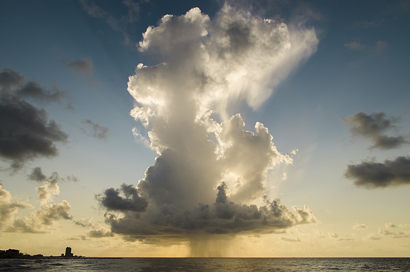
Image courtesy of Wikimedia
🤝Connect with other students studying Earth Science with Hours
Types of Clouds
4 min read•december 9, 2021
Sitara H
Sitara H
Types of Clouds
How Clouds Form
Not all clouds are created equal. Clouds have different names based on their shape and height above the Earth. We can also categorize them into other groups in two ways: either by height or by their unique characteristics. ⛅
Cloud Group + Height | Cloud Types |
High Clouds: 5-13 km above Earth’s surface | Cirrus, Cirrocumulus, Cirrostratus |
Middle Clouds: 2-7 km | Altocumulus, Altostratus |
Low Clouds: Surface-2 km | Stratus, Stratocumulus, Nimbostratus |
Clouds with Vertical Growth: clouds that grow upwards, instead of spreading out | Cumulus, Cumulonimbus |
Unusual Clouds: Clouds that form in unique ways, not grouped by height | Lenticular |
High-Level Clouds
1 Cirrus
Cirrus clouds are one of the most common cloud types and can be seen at any time throughout the year. They have a thin and wispy appearance due to the ice crystals that make them. The level of separation between these crystals determines how transparent the cloud is. 💎
They also stand out because they are often seen in different colors as the sun rises and sets; they stay lit much longer than other clouds. Cirrus clouds are located far above us, 20,000 to 40,000 feet near their base. They often form in advance of a warm front when clouds meet at high levels. ☝
Image courtesy of Wikimedia
2 Cirrocumulus
These clouds form with small, white fluffy patterns and spread out for miles in the sky. They can sometimes have a greyish color that gives them the nickname “mackerel skies.” 🐟
It’s important to remember that cirrocumulus clouds never generate rainfall (but they can still indicate incoming cold weather), nor do they ever interact with other types of clouds to form larger cloud structures. 🌂🙅♂️
3 Cirrostratus
They have a sheet-like greyish and a pretty translucent appearance. Purely white cirrostratus clouds signify stored moisture, which indicates the presence of a warm frontal system. 🔥
Middle-Level Clouds
1 Altocumulus
Altocumulus clouds form at a lower altitude, so water droplets make up a higher percentage of their makeup. When they appear with other types of clouds simultaneously, storms typically follow with light to moderate rainfall. ❗
They are pretty common in most parts of the world! 🌎
2 Altostratus
These clouds are often spread over huge areas and are strongly linked to light rainfall and snowfall. They are also known as "boring clouds" because they are uniformly gray, smooth, and featureless. 😩
3 Nimbostratus
These clouds are the textbook definition of "rain clouds": they tend to form thick and dark layers that block out the Sun, and they develop as a result of moisture gradually accumulating over a large area. 🌞
Low-Level Clouds
1 Stratus
Stratus clouds are composed of thin layers of clouds that cover large sky areas. They form from large air masses rising and condensing, occasionally producing light rainfall or snowfall. The long horizontal cloud layers are easily distinguishable, which gives off a foggy look. 🌁
They are widespread, especially in coastal and mountainous areas. 🗻
Image courtesy of Wikimedia
2 Stratocumulus
These resemble cumulus clouds, except far bigger. Depending on the thickness of the cloud, stratocumulus clouds have varying gray hues. Despite their intimidating look, they produce very little rainfall! 💭
In line with their resemblance to flattened waves of clouds, their name means “flattened heap”! 🥿
They tend to form from the disintegration of an already-formed stratus cloud and are usually an indicator of a change in weather patterns—they can usually be found along warm or cold fronts as a result! ✨
Clouds with Vertical Growth
1 Cumulus
The most recognizable out of all the cloud types, they are a sign of fair weather for sure. If conditions allow, they can occasionally produce light showers and grow into cumulonimbus clouds, and they can be found virtually everywhere in the world. 🌳
They can range anywhere from 1200 to 6500 feet, and their name comes from the Latin word for “heap,” cumulus. They form through convection as hot air rises and cools when it reaches higher altitudes, condensing to form these tall clouds. 💪
Image courtesy of Wikimedia
2 Cumulonimbus
They are rather fluffy and white, just like cumulus clouds, but they are much larger and taller in size: usually about 1100 to 6500 feet. Their icy tops generally characterize them. 🧊
These clouds often bring thunderstorms and are most commonly seen during spring and summer afternoons. Most widely known as thunderclouds, cumulonimbus clouds are the only type that can produce heavy precipitation and weather conditions like thunder and lightning. ⚡
Image courtesy of Wikimedia
🤝Connect with other students studying Earth Science with Hours
Resources
© 2024 Fiveable Inc. All rights reserved.
AP® and SAT® are trademarks registered by the College Board, which is not affiliated with, and does not endorse this website.