⛏️Intro to Geology Unit 1 Review
1.4 Scientific methods in geology
1.4 Scientific methods in geology
Unit & Topic Study Guides
Earth's Structure in Geology
Minerals: The Foundation of Rocks
Igneous Rocks: Formation and Intrusion
Volcanoes and Volcanic Hazards
Weathering, Erosion, and Soil
Sedimentary Rocks and Their Environments
Metamorphic Rocks: Processes & Types
Geologic Time and Earth's History
Crustal Deformation & Structural Geology
Earthquakes and Seismic Hazards
Plate Tectonics: Earth's Dynamic Interior
Surficial Processes and Landforms
Groundwater and Hydrogeology
Energy and Mineral Resources
Scientific Methods in Geology
Geologists study processes that often span millions of years and occur deep beneath Earth's surface. You can't exactly run a quick experiment on a volcanic eruption or watch a mountain range form in real time. That's why the scientific method in geology relies heavily on fieldwork, lab analysis, and modeling to gather indirect evidence and build explanations for what we observe.
The Scientific Method in Geology
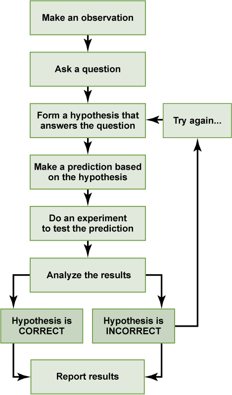
The scientific method works the same way in geology as in any other science, but the types of evidence and testing look different. Here are the core steps:
- Observation and question formulation — Notice something in the natural world (an unusual rock formation, a pattern of earthquakes along a coastline) and ask why or how it formed.
- Hypothesis development — Propose a testable explanation based on what you already know. For example: "This layer of sandstone was deposited in a shallow marine environment."
- Prediction — If the hypothesis is true, what else should you expect to find? ("If this sandstone is marine, we should find fossils of marine organisms in it.")
- Testing through data collection — Design fieldwork, lab tests, or models to check your prediction. Collect rock samples, take measurements, run analyses.
- Analysis of results — Process your data using appropriate techniques (statistical analysis, geochemical methods) and determine whether the results support or contradict your hypothesis.
- Conclusion and revision — Draw conclusions from your analysis. If the data don't support your hypothesis, revise it and test again. This cycle repeats as understanding improves.
The key difference in geology is that you often can't do controlled lab experiments the way a chemist can. Instead, geologists treat the natural world as their experiment, looking for evidence that already exists in rocks, landforms, and seismic records.
Components of Geological Investigations
Observation
Every geological investigation starts with careful observation. This means identifying and describing features like rock types, structures, and landforms, as well as active processes like erosion or volcanic activity.
Geologists collect both qualitative data (descriptions of rock color, texture, grain size) and quantitative data (measurements of bed orientation using strike and dip, GPS coordinates of outcrops, thickness of rock layers). All of this gets recorded systematically through field notes, annotated sketches, photographs, and digital measurements so it can be analyzed later.
Hypothesis Testing
Once you have observations, you develop a hypothesis that can actually be tested. A good geological hypothesis is specific enough to make predictions. For example: "This fault caused the 2011 earthquake" is testable because you can measure fault plane orientations, analyze seismic recordings, and check whether the data match.
Testing involves:
- Designing a study or set of measurements that would produce different results depending on whether the hypothesis is right or wrong
- Collecting the relevant data (seismic records, rock samples, chemical compositions)
- Analyzing that data with appropriate methods (seismic waveform analysis, petrographic microscopy) to evaluate the evidence
Data Analysis
Raw data doesn't tell you much on its own. Geologists organize their data into databases, maps, and cross-sections, then apply statistical methods to find trends and patterns. For instance, you might plot earthquake epicenters on a map and discover they cluster along a previously unmapped fault.
Interpreting results always means connecting back to your original question and hypothesis. You also need to evaluate reliability: Are there sources of error? Do other studies support your findings? Strong conclusions come from multiple lines of evidence pointing the same direction.

Methods in Geological Research
Fieldwork
Fieldwork is the foundation of geology. This is where you collect data and samples directly from outcrops, riverbeds, cliff faces, and other natural exposures. You observe geological features in their actual spatial context, noting how rock layers relate to each other, where faults cut through formations, and how structures are oriented.
Field evidence like crosscutting relationships (a dike cutting through older rock tells you the dike is younger) and kinematic indicators (features showing the direction a fault moved) directly tests hypotheses about geological history. The samples and measurements collected in the field also provide the raw material for lab work and modeling.
Laboratory Analysis
Lab work lets you examine field samples at a level of detail that isn't possible outdoors. Common techniques include:
- Microscopy — Optical and electron microscopes reveal the texture, mineral composition, and internal structure of rocks at very small scales. A thin section of rock under a polarizing microscope can tell you exactly what minerals are present and how they formed.
- Geochemical analysis — Techniques like X-ray fluorescence (XRF) and mass spectrometry determine the chemical composition and isotopic ratios of geological materials, which can reveal where a rock originated or what conditions it formed under.
- Radiometric dating — Methods like potassium-argon and uranium-lead dating use the predictable decay of radioactive isotopes to determine the age of rocks and minerals. This is how geologists build absolute timelines of Earth's history.
Lab results complement field observations by providing high-resolution data (crystal structures, precise chemical signatures) that sharpen your understanding of what you saw in the field.
Modeling
Many geological processes are too slow, too large, or too deep to observe directly. Models fill that gap by creating simplified representations of complex systems. There are three main types:
- Conceptual models — Qualitative diagrams or descriptions that capture the key elements of a system. A block diagram showing how sediment moves from mountains to a river delta is a conceptual model.
- Mathematical models — Equations that quantitatively describe geological processes, such as heat transfer in Earth's interior or the rate of groundwater flow through porous rock.
- Computational models — Computer simulations that model how geological systems evolve over time, like landscape erosion over millions of years or seismic wave propagation through different rock layers.
Models are especially useful for testing hypotheses and exploring "what if" scenarios. For example, you could model how different tectonic stress conditions would affect slip on a fault, then compare the model's predictions to actual seismic data. The best models integrate field measurements, lab results, and geophysical survey data to produce the most realistic picture possible.