Archaeological documentation is crucial for preserving Greek heritage. Meticulous recording of excavations, artifacts, and site layouts allows researchers to piece together ancient histories. From field notes to 3D scans, these methods capture vital data for understanding past cultures.
Accurate documentation supports interpretation, conservation, and public education. By creating detailed records, archaeologists ensure that Greek sites can be studied for generations to come. This careful approach helps unlock the secrets of ancient civilizations and their enduring impact.
Archaeological Documentation in Greek Sites
Essential Elements of Documentation
- Field notes detail excavated features, artifacts, and contexts
- Drawings provide visual representations of site layouts and findings
- Photographs capture visual records of excavation processes and discoveries
- Digital records store and organize all collected data
- Stratigraphic recording documents soil layers and their relationships
- Establishes chronological sequences of site occupation
- Identifies associations between artifacts and soil contexts
- Spatial documentation maps site layouts and artifact distributions
- Utilizes grid systems for precise locational recording
- Employs total stations or GPS technology for accurate mapping
- Artifact cataloging systems assign unique identifiers to each find
- Include detailed descriptions of physical characteristics
- Record measurements, material composition, and contextual information
- Conservation methods documentation ensures proper preservation
- Records treatments applied to artifacts and structures on-site
- Enables future research and conservation efforts
- Environmental and geological data collection reconstructs past environments
- Involves systematic recording of soil samples
- Includes documentation of botanical remains and faunal evidence
- Digital documentation techniques create comprehensive records
- 3D modeling captures complex structures and artifacts
- Photogrammetry generates detailed visual representations
- GIS mapping integrates spatial data for analysis and visualization
Advanced Documentation Methods
- Field journals systematically record daily activities and observations
- Standardized recording forms ensure consistent data collection across excavation teams
- Scale drawings depict excavation units and features
- Provide visual documentation of spatial relationships
- Include measurements and orientations of archaeological features
- Photography techniques create high-quality visual records
- Utilize scale bars for size reference (meter sticks, photographic scales)
- Include north arrows for orientation
- Employ proper lighting to highlight important details
- Total station surveys generate accurate site plans
- Record precise locations of features and artifacts
- Create topographic maps of site terrain
- GPS mapping enhances spatial accuracy of recorded data
- Allows for integration with GIS software for analysis
- Facilitates creation of digital site maps
- Laser scanning captures intricate details of complex structures
- Produces high-resolution 3D models of architectural features
- Enables virtual reconstruction of damaged or fragmented artifacts
- Photogrammetry techniques generate 3D models from multiple photographs
- Creates detailed representations of entire sites or individual objects
- Allows for virtual exploration and analysis of archaeological contexts
- Systematic sampling strategies collect materials for laboratory analysis
- Soil samples for sediment analysis and dating
- Botanical samples for paleoenvironmental reconstruction
- Faunal remains for diet and subsistence studies
- Digital data management systems organize and integrate various data types
- Centralize storage of field notes, photographs, and spatial data
- Enable efficient retrieval and analysis of archaeological information

Recording Archaeological Data in the Field
Field Documentation Techniques
- Field journals record daily activities, observations, and interpretations
- Include detailed descriptions of excavation progress
- Document weather conditions and other factors affecting fieldwork
- Standardized recording forms ensure consistent data collection
- Artifact record sheets capture essential information for each find
- Context sheets document stratigraphic units and features
- Scale drawings visually document excavation units and features
- Use graph paper or digital tablets for precise measurements
- Include multiple views (plan, profile) for comprehensive representation
- Photography techniques create visual records of excavation process
- Employ scale bars to provide size reference in images
- Use north arrows to indicate orientation of photographed features
- Ensure proper lighting to highlight important details and textures
- Total station surveys generate accurate site plans and artifact locations
- Record x, y, and z coordinates for precise spatial documentation
- Create detailed topographic maps of site terrain
- GPS mapping enhances spatial accuracy of recorded data
- Allows for integration with GIS software for spatial analysis
- Facilitates creation of digital site maps and distribution plots
- Laser scanning captures intricate details of complex structures
- Produces high-resolution 3D models of architectural features (temples, theatres)
- Enables virtual reconstruction of damaged or fragmented artifacts (statues, friezes)
- Photogrammetry techniques generate 3D models from multiple photographs
- Creates detailed representations of entire sites (Delphi, Olympia)
- Allows for virtual exploration and analysis of archaeological contexts
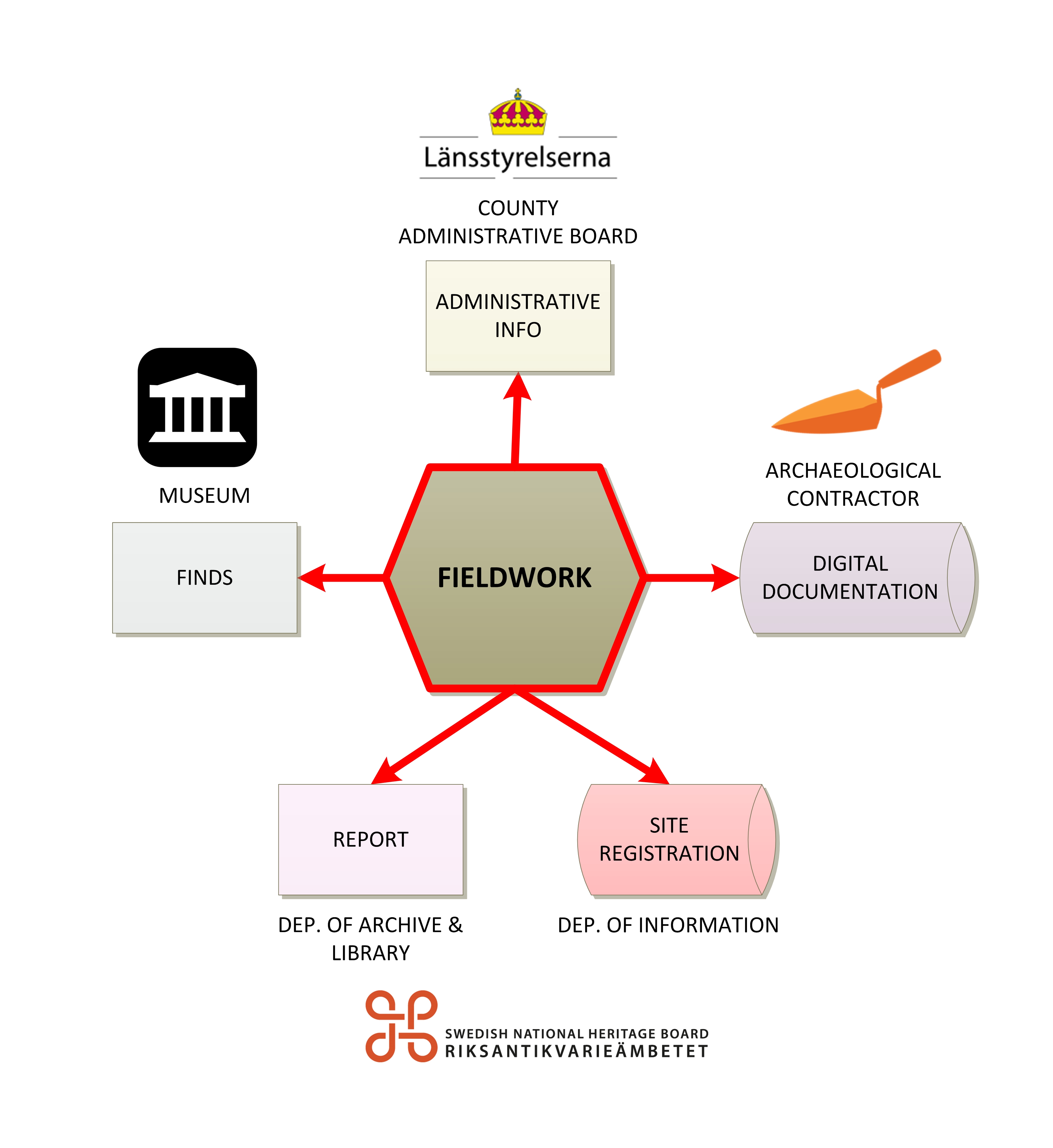
Sampling and Data Management
- Systematic sampling strategies collect materials for laboratory analysis
- Soil samples for sediment analysis and radiocarbon dating
- Botanical samples for paleoenvironmental reconstruction (pollen, charcoal)
- Faunal remains for diet and subsistence studies (animal bones, shells)
- Digital data management systems organize and integrate various data types
- Centralize storage of field notes, photographs, and spatial data
- Enable efficient retrieval and analysis of archaeological information
- Database design incorporates relational structures for data organization
- Links artifact records to their excavation contexts
- Associates photographs and drawings with specific features or finds
- Data backup protocols ensure preservation of digital records
- Regular backups to multiple storage devices or cloud services
- Creation of redundant copies to prevent data loss
- Metadata documentation provides context for collected data
- Includes information on data collection methods and equipment used
- Records names of excavators and dates of data entry
- Data standardization facilitates integration and comparison
- Use of controlled vocabularies for artifact and feature descriptions
- Adoption of standardized measurement units and recording conventions
Importance of Accurate Recording for Greek Heritage
Interpretation and Analysis
- Accurate recording ensures integrity of archaeological data
- Enables reliable interpretation of site chronology and function
- Supports understanding of cultural significance and historical context
- Systematic documentation allows future researchers to revisit findings
- Facilitates reinterpretation of data as new theories emerge
- Enables continued study even after physical site alteration or destruction
- Detailed records aid reconstruction of site formation processes
- Helps understand complex stratigraphic relationships in Greek contexts
- Reveals patterns of site use and abandonment over time
- Comprehensive documentation supports development of site narratives
- Enables creation of coherent historical accounts based on material evidence
- Facilitates interpretation of social, economic, and political aspects of past societies
- Accurate recording allows integration of data from multiple Greek sites
- Enables broader regional comparisons (Attica, Peloponnese, Aegean islands)
- Supports chronological syntheses across different periods (Archaic, Classical, Hellenistic)
Conservation and Management
- Detailed records facilitate development of conservation plans
- Guides prioritization of preservation efforts for vulnerable artifacts and structures
- Informs selection of appropriate conservation treatments and materials
- Systematic documentation supports site management strategies
- Aids in assessing site conditions and monitoring changes over time
- Informs decisions on visitor access and site presentation
- Accurate recording ensures compliance with heritage laws and standards
- Meets requirements of Greek antiquities legislation
- Adheres to international ethical standards in archaeological practice
- Comprehensive documentation enhances public education and outreach
- Provides basis for museum exhibits and interpretive materials
- Supports development of virtual reconstructions and interactive displays
- Proper recording techniques preserve information for future generations
- Creates lasting record of Greek cultural heritage
- Ensures continuity of knowledge even if sites are damaged or lost